CONVECTIVE FORECAST
VALID Fri 25 Nov 06:00 - Sat 26 Nov 06:00 2005 (UTC)
ISSUED: 24 Nov 22:02 (UTC)
FORECASTER: TUSCHY
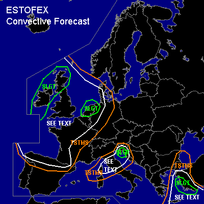
There is a slight risk of severe thunderstorms forecast across the eastern Aegean Sea and western Turkey
There is a slight risk of severe thunderstorms forecast across northwestern coastal areas of Croatia and western Slovenia
There is a slight risk of severe thunderstorms forecast across the Netherlands,extreme northwestern Germany,Ireland and the northern areas of United Kingdom
SYNOPSIS
An impressive outbreak of Arctic airmass will be ongoing during the 24h forecast period and an outstanding well developed polar vortex will be centered over NW Europe...150kt+ UL jet on the western side of this vortex will help for continuing amplification and this jet will reach the extreme N-coast of Africa during the latter part of the forecast period....Downstream of this system,strong and separated polarfront/subtropical jet will support WAA for SE Europe, while ridging will induce stable conditions over NE Europe .
DISCUSSION
...the eastern Aegean Sea and western Turkey...
Intense subtropical jet // H5 up to 90kt // will be placed over the SE Mediterranean area and its thermally indirect circulation of the left exit region and slowly SW-ward shifting cold front will induce enough lift for scattered TSTM initiation...Some uncertainness will be present... models,like GFS, show some low-end CIN values south of Turkey and forecast sounding from Heraklion also has a relatively dry mid-level airmass, which could reduce storm coverage... IR loop also shows thick CI-shield which should limit insolation and the development of some instability...Otherwise, parameters will be conducive for a few organized storms... GFS shows 100 - 400 J/Kg SBCAPE in the SLGT risk area and I see now reason why those steep LL rates from Greece (Athinai, 24.Nov 12Z )won't be materialized tomorrow over SW Turkey...LL shear of 12-15m/s , DLS about 30m/s and a veering wind profile will be more than adequate for an enhanced tornado/ severe wind gust threat.. especially along the coastal areas, where we will find the best chance for a few surface based storms....Only very slowly SE-ward shifting baroclinic zone( aligned nearly parallel towards the background flow )and continuing advection of higher PWAT values from the SW will favor a flash flood risk especially in the southern half of the risk area.
...northwestern coastal areas of Croatia and western Slovenia...
Cold front, racing southward over central Europe, will arrive in the northern Mediterranean areas during the morning hours...Strong CAA and entering strong polar front jet will induce weak LL cyclogenesis over the Ligurian Sea...This depression is forecasted to travel ENE-ward along a strengthening baroclinic zone over N-Italy....Although instability release in the SEE TEXT area will be only marginal ( locally about 300 J/kg SBCAPE ), expect isolated to scattered TSTMS development...Forecast soundings show that the storms over central Italy will tend to be elevated... but GFS and ECMWF also show strong and persistent onshore flow over the SLGT area, downstream of developing depression... This augments the threat for a few surface based storms in an environment with impressive LL shear (up to 20m/s ) especially along the coastal areas... Main risk will be a few tornadoes / severe wind gusts.
...the Netherlands,extreme northwestern Germany,Ireland and the northern areas of United Kingdom...
Pool of very cold mid-level air will spread southward on the western side of the polar vortex...reaching northern Portugal/Spain and southern France during the noon/afternoon hours...Steepening mid-level lapse rates, very steep LL lapse rates,caused by warm SSTs // 11-13°C around the English Channel and 15°C+ in the Bay of Biscaya //will provide widespread SB CAPE release ( up to 500 J/kg possible )...Expect the chance for scattered TSTM development in the whole SEE TEXT area, especially along the coastal areas of Scotland,France,Spain and Portugal... Main risk will be a few tornadoes as a consequence of enhanced LL shear and a marginal hail threat.
First area of an enhanced severe weather risk will be the Netherlands and NW Germany...Main reason for upgrading was a consistent model forecast of a developing H85 streak and De Bilt forecast sounding for 21-00Z at 26.11. which shows 50kt in an environment with very steep LL lapse rates...Although models don't forecast more than 100 J/kg instability in the risk area, current thinking is that forcing of a southward moving trough axis from the western North Sea will help for some additional lift during the early night hours...Under the base of the polar vortex, weak DLS along the coastal areas will favor the risk for a few waterspouts... Further inland, shallow convective showers/electrified storms should develop in an environment with enhanced LL-CAPE/-shear which would pose a risk for severe wind gusts and one or two tornadoes.
The second area will be Scotland and Ireland... A southward moving short wave trough during the evening hours will enhance the LL shear over the risk areas with an attendant threat for a few tornadoes/marginal hail...Also included Ireland in a conditional SLGT area, although a shift of the wind direction more towards the northeast during the approach of the short wave would mean that the fetch for moistening of the low-level airmass could be too short... combined with a drying trend of the airmass in the lee of the Scotland Highlands ...resulting in a possibly diminishing convection trend over this area.
#