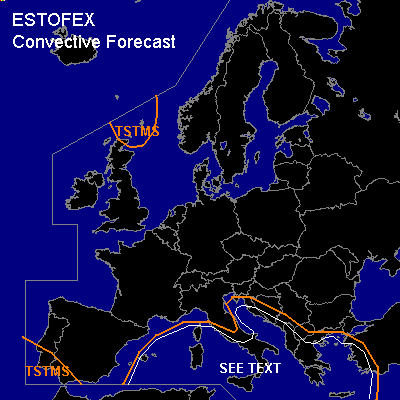

CONVECTIVE FORECAST
VALID Wed 23 Nov 09:00 - Thu 24 Nov 06:00 2005 (UTC)
ISSUED: 23 Nov 08:57 (UTC)
FORECASTER: GATZEN
SYNOPSIS
Well-developed high-over-low pattern has built over Europe ... with intense and large cut-off low over central Mediterranean/Alpine region and high geopotential from British Isles to western Russia. At lower levels ... cold polar airmass has spread into western and northern Mediterranean and should advect into central Mediterranean behind a propagating cold front.
DISCUSSION
...Mediterranean...
East of a frontal boundary moving eastward over central Mediterranean ... relatively warm and moist airmass is present ... and steep lapse rates and low level moisture create some 100 J/kg low-level CAPE as indicated by latest Trapani sounding. Showers and thunderstorms have developed in the range of this airmass. Rather strong vertical wind shear and QG forcing is present ... and relatively well-organized storms have formed during the last couple of hours. Expect that this acticity will spread eastward during the period. Given low-level CAPE and shear ... multicells and mesocyclones are expected to form ... capable of producing severe wind gusts and probably waterspouts and one or two tornadoes. However ... QG forcing should weaken as upper low remains over central Mediterranean ... and cold airmass is expected to lead to stabilization. Overall threat should be too low for a SLGT. To the west ... polar airmass is characterized by steep low-level lapse rates and poor low-level moisture. However ... warm sea surface has proved to lead to shallow showers and thunderstorms. Given strong vertical wind shear at the southern flank ov the cut-off low ... a few organized cells are expected ... with severe wind gusts the main threat. A few waterspouts/tornadoes are not ruled out.
#