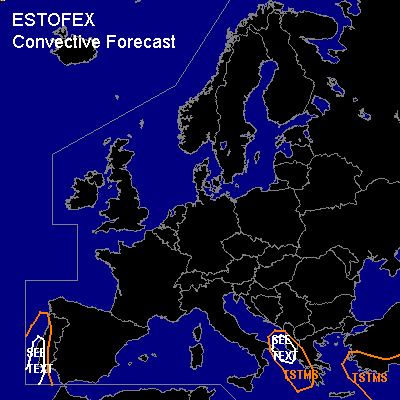
CONVECTIVE FORECAST
VALID Fri 18 Nov 06:00 - Sat 19 Nov 06:00 2005 (UTC)
ISSUED: 17 Nov 17:17 (UTC)
FORECASTER: TUSCHY
SYNOPSIS
Highly amplified weather pattern is ongoing during the next 24 hours...Major trough with adjacent strong CAA will help for cool and stable conditions over most parts of northern and central Germany... Some low-level moistening of this airmass over the North Sea should help for isolated TSTM development over NW Germany and the Netherlands but strengthening high pressure area over United Kingdom should help to limit TSTM coverage---even more than the past few days, where only a few SFLOC datas were reported.
Strong cut-off will develop over the extreme eastern Atlantic Ocean with strong LL cyclogenesis forecasted west of Spain/Portugal.
DISCUSSION
...western and southern Portugal...
Developing strong LL low pressure system west of Spain/Portugal will help for strengthening onshore flow along the coastal areas of W/SW Portugal and slightly higher dewpoints will be advected well inland...Timing of cold front arrival was adjusted back for a few hours (GFS at ~ 21Z) which will limit surface based storm development...but ATM, uncertainness of exact front arrival and prefrontal airmass recovery in mind, don't want to exclude, that an isolated TSTM will develop in the SEE TEXT area... LL shear only becomes stronger by time ( about 12-15m/s) and one or two tornadoes/ a few severe wind gusts can't be ruled out.
...western Greece and Albania...
At the tip of impressive central Europe longwave trough, pretty broad area with lower low low-level pressure present over SE Italy...this,combined with some UL divergence, should help for a few TSTMS to develop... LL shear only marginal but could be locally enhanced along the coastal areas....Strong DLS in the order of 20m/s+ present and current thinking is that especially the northern TSTM area // best kinematic and thermodynamic parameters // will see a few TSTMs to develop with an isolated severe wind gust threat.
#