CONVECTIVE FORECAST
VALID Tue 15 Nov 06:00 - Wed 16 Nov 06:00 2005 (UTC)
ISSUED: 15 Nov 09:33 (UTC)
FORECASTER: VAN DER VELDE
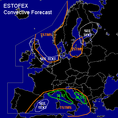
There is a slight risk of severe thunderstorms forecast across western Italy, southeastern France, eastern Adriatic coast
SYNOPSIS
A weak low MSL pressure area is present over the Mediterranean Sea with a upper cut-off low over eastern Spain. A tongue of highest theta-e and convergent low level winds stays stationary along the west coast of Italy into southern France. This zone and associated convective activity is shifting slowly eastward into the Adriatic sea.
Over northern Europe, a cold maritime airmass within the upper longwave trough behind the cold front that crosses Finland and the Baltic States today. Strongest convection is expected along the Norwegian coast and over Scotland into the northern Benelux/Germany area in the early morning of Wednesday due to a shortwave trough.
DISCUSSION
...SLGTs over western Italy, and Adriatic...
Stationary convection at the beginning of the FCST period over western Italy is associated with a tongue of low-level convergence and moisture/heat transport northwestward, while deep layer (15-25 m/s) and low-level shear (0-3 km helicity 100-300 m2/s2) conditions support a stable configuration of storm systems and updraft rotation (supercells). Expect MLCAPE range from 700-1200 J/kg. GFS 00Z has 0-1 km shear over 10 m/s and with LCLs under 500-1000 m and a rotating updraft this may spawn tornadoes. However, NMM 00Z does not feature such high shear and SREH values, as also 00Z Pratica sounding shows despite strong veering winds with height, and convection may be partly elevated. Do expect persistent storms with a chance of large hail or a tornado, and large sums of precipitation inducing local flooding.
...Balearic Islands...
As models do not give a very strong zone of low-level convergence anymore, storm activity (few hundred J/kg MLCAPE) will be less focused than earlier this week, however the flow is weak and any storms may remain stationary and cause flash flooding. Also, in local convergence zones with strong updrafts waterspouts may develop.
...Finland, Estland, NW Russia...
00Z Jokioinen shows a 2 km deep neutral saturated layer that may allow shallow convection along the cold front. There is a marginal risk of tornadoes due to the strong low-level shear (925-850 hPa winds > 35 kts) and very low LCLs if any convection manages to develop.
...Scotland into Netherlands...
Strong deep layer shear under the jetstream and strong low-level winds (-shear) could potentially cause updraft rotation and tornadoes with the convection associated with the shortwave trough that affects the western and southern North Sea. Convection is expected to barely reach the -15C level, so that thunderous activity is not expected to be significant, if anything, except if the trough manages to organize storms into a well defined linear feature. Convective gusts could reach over 20 m/s in the UK.
#