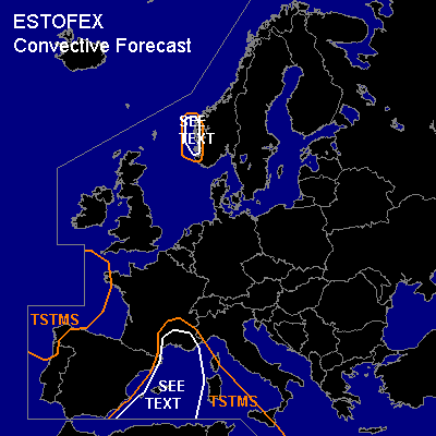

CONVECTIVE FORECAST
VALID Sat 12 Nov 09:00 - Sun 13 Nov 06:00 2005 (UTC)
ISSUED: 12 Nov 09:23 (UTC)
FORECASTER: DAHL
SYNOPSIS
As longwave trough over the E Atlantic/W Europe digs southward ... it will merge with the upper cut-off low now over W Algeria ... and in addition will promote cyclogenesis over the Iberian Peninsula in the late evening hours and during the night. Intense SFC low ATTM NE of the British Isles ... is progged to weaken and continue its eastward track ... crossing S Norway late in the period.
DISCUSSION
...W Mediterranean...
GFS advertises CAPE in excess of 1000 J/kg over the W Mediterranean ... which is not backed up by observational data ... though numerical analyses suggest that maximum of LL moisture has been located just between the available upper-air stations at 00Z ... and somewhat higher CAPE than what is revealed by the 00Z soundings may thus be present.
Deep shear should remain fairly weak with about 10 m/s ... while low-level shear might increase somewhat over the NW Mediterranean in response to falling pressures over Iberia late in the period. Expect a few waterspouts given little/no capping and nearly saturated boundary layers ... but organized severe threat seems to be rather limited.
...S Norway...
A few shallow TSTMS could occur in strong upslope flow regime along the S Norwegian Mountains. Already strong large-scale flow will likely be augmented by downward mixing of momentum by the convection ... with the strongest gusts expected to exceed severe limits. Lightning activity may be limited given shallow nature of the storms.
...Gulf of Biscay...
Depth of cellular convection currently advecting into the Gulf of Biscay ... should increase as trough closes off into a cut-off low. As usual ... depth of convective mixing will decrease towards the periphery of the upper low ... where shear profiles should increase. ATTM confidence is limited that this activity will pose much of a severe weather threat ... though small hail and strong wind gusts could occur.
#