CONVECTIVE FORECAST
VALID Fri 11 Nov 06:00 - Sat 12 Nov 06:00 2005 (UTC)
ISSUED: 10 Nov 17:19 (UTC)
FORECASTER: TUSCHY
SYNOPSIS
Rapidly intensifying low pressure system will arrive in Ireland and United Kingdom/Scotland during the noon hours , racing east/northeastward and will be placed somewhere east of the Faeroe Islands during the latter part of the forecast period...Accompanying UL trough // still positively tilted at 18 UTC,yesterday // helped for establishing a short-lived but strong WAA regime over parts of NW Europe, building up a weak ridge( extending over W-CNTRL Europe)...This strengthening ridge helped to push the cut-off low over SW Europe further to the south/southwest and this displacement trend will continue during the forecast period....also gradually weakening of this system forecasted by the model pool....Most parts of central and eastern Europe will see high pressure with stable conditions...parts of extreme northern Europe will be influenced by a weakening area of low pressure.
DISCUSSION
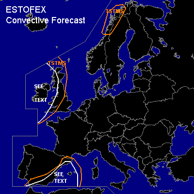
...Ireland and United Kingdom...
Not easy to determine the exact spots, concerning enhanced convection, in such an intense storm system that far out... but there are signs for 3 different areas, where increased TSTM development will be possible.
First round of isolated TSTM development should be found during the cold front passage, where isolated embedded storms can develop....NMM showed some prefrontal low-end instability and each developing storm would be in an environment, conducive for severe - damaging wind gusts... Exact dry slot position also important for some TSTM development in its tip, as a result of release of enhanced potential instability.
During the late evening hours, intense low pressure system will be placed somewhere north of Scotland...GFS and NMM show slight instability, possibly overlapping with impressive LL shear values up to 17m/s+...Main risk would be an enhanced tornado threat...however uncertainness of strength of wrap-around moisture and exact center-location precludes me for issuing a risk category ATM.
The last region of interest will be Ireland where short wave trough will slide southward during the night hours... Impressive mid-level cold pool, 200-300 J/kg SBCAPE ( mainly over southern Ireland and offshore ) and accompanying forcing should be enough for isolated to scattered TSTMs...weak kinematic parameters are not favorable for storm organisation but there will be a risk for marginal hail.
...eastern Spain,Strait of Gibraltar and the Balearic Sea...
Cut-off system will weaken considerably during the next 24 hours...background flow will also start to diminish but DLS locally up to 20m/s should pose a risk for a few severe wind gusts...risk for a few waterspouts over the Street of Gibraltar should rise somewhat , when core of cut-off system will reach the region during the latter part of the forecast period.
...coastal areas of northern Norway...
Isolated TSTM development expected along the coastal areas as a consequence of weakening and slowly northward propagating low-level depression...LL shear up to 12m/s along the coastal areas will be enough for an isolated, marginal hail threat and one or tow tornadoes.
#