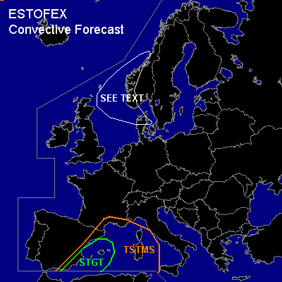

CONVECTIVE FORECAST
VALID Thu 10 Nov 06:00 - Fri 11 Nov 06:00 2005 (UTC)
ISSUED: 09 Nov 21:20 (UTC)
FORECASTER: GATZEN
There is a slight risk of severe thunderstorms forecast across western Mediterranean
SYNOPSIS
High pressure builds from eastern Atlantic to France and further to eastern Europe. Upper cut-off low over southwestern Mediterranean is expected to digg southwestward at the southern flank of European high. To the north ... strong polar jet affects British Isles, Scandinavia, and northwestern Russia. Strong vort-maxima/short-wave troughs are embedded in the strong current.
DISCUSSION
...Western Mediterranean...
Thunderstorms have formed in the range of upper cut-off low over western Mediterranean on Wednesday. Unfortunately, Palma de Mallorca 12 UTC sounding is missing ... and thermodynamic environment is not known ATTM. Expect that latest GFS CAPE calculations are realistic ... given rather steep low-level lapse rates at Murcia in the range of the cut-off and rich low-level moisture at Cagliari. On Thursday ... models suggest that upper cut-off will digg southwestward. Relatively warm and moist low-level airmass should remain over western Mediterranean as low-level winds turn to easterly directions. Aloft ... strong southerly jet is expected to affect extremely western Mediterranean ... where vertical wind shear should be quite strong and QG forcing should lead to ongoing convective activity. As a consequence ... another round of organized thunderstorms is forecast ... and supercells/multicells may form, capable of producing severe wind gusts, a few tornadoes, and large hail. Thunderstorms may merge into one or two MCS during the period ... with severe wind gusts and local flash flooding the main threat. Allover threat seems to be comparable to Wednesday's outlook.
...Northern North Sea
...
Showers and a few thunderstorms are expected in the range of rapidely propagating short-wave trough. Strong vertical wind shear is present ... and severe wind gusts should be likely with any organized multicell/mesocyclone that forms. However ... weak instability is expected ... and chance for thunderstroms should be too low for a TSTMS.
#