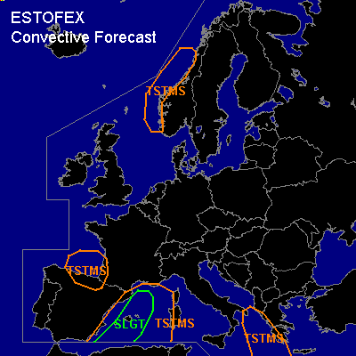

CONVECTIVE FORECAST
VALID Wed 09 Nov 06:00 - Thu 10 Nov 06:00 2005 (UTC)
ISSUED: 08 Nov 21:31 (UTC)
FORECASTER: GATZEN
There is a slight risk of severe thunderstorms forecast across western Mediterranean
SYNOPSIS
Broad high covers eastern Europe. Over western Europe ... sharp amplified upper trough cuts off into southwestern Mediterranean. At lower levels ... cold airmass spreads into Iberian Peninsula and central Europe in the range of remaining short-wave trough that crosses western Scandinavia and western central Europe during the period.
DISCUSSION
...Western Mediterranean...
Stable airmass is present over western Mediterranean ... characterized by a strong inversion from 900 to 750 hPa and quite steep lapse rates aloft. In the boundary layer ... low-level moisture has reached 8 g/kg over Palma de Mallorca. On Wednesday ... intense QG forcing is expected in the range of propagating cut off low ... and latest GFS model run shows increasing instability during the period. Due to quite rich low-level moisture ... current thinking is that GFS CAPE forecast is reasonable and CAPE should reach several 100 J/kg. At the 500 hPa level ... strong upper jet streak is forecast to curve around the upper cut-off ... and is expected to cross the region of instability. Intense DCVA and weak temperature advection is expected to result in quite strong QG forcing ... and cyclogenesis/low level convergence is forecast by latest model output. Showers and thunderstorms are expected to form during the day. Thunderstorms that form are expected to organize given 25+ m/s DLS and enhanced LLS. Multicells and supercells may form ... capable of producing severe wind gusts and isolated large hail. Chance for tornadoes should be slightly enhanced given relatively strong LLS. Thunderstorms should go on during the evening/night hours while merging into one/two MCS ... with severe wind gusts the most significant threat. Allover threat seems to warrant a SLGT RISK.
#