CONVECTIVE FORECAST
VALID Tue 08 Nov 06:00 - Wed 09 Nov 06:00 2005 (UTC)
ISSUED: 08 Nov 09:36 (UTC)
FORECASTER: VAN DER VELDE
SYNOPSIS
An elongated upper trough filled with cold air spans out to the Iberian Peninsula. A cold front at the DCVA side of the trough will progress into western France later in the period, while a wave over the British Isles shifts into Norway without much development.
A tongue of theta-e and convergence is situated over the Adriatic/Ionian Sea.
DISCUSSION
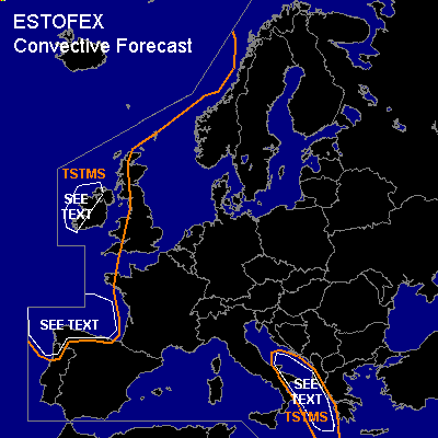
...northwestern Spain...
Behind the cold front, enhanced convection from the ocean will arrive within the cold airmass and behind any significant vertical wind shear. Some risk of spout-type tornadoes is present given the expected steep lapse rates, strong low-level buoyancy and weak winds, especially if there is some linear organisation in convection.
...Adriatic/Ionian Sea...
No 00Z profiles available in the vicinity, but IR loop shows convection with also some sferics. GFS indicates strong LL buoyancy, low LFC and weak flow conditions. Expect some waterspouts to occur in the convergence zone.
...western Ireland...
Deep convection over the ocean is arriving at the Irish west coast. Since low-level lapse rates are steep and the flow is minimal, while vorticity is enhanced within the trough, some convective cells may generate waterspouts.
By 00Z, a northwest jet and stronger LL shear will arrive over the region, but convective depth should be less by then in the zone of negative DCVA, limiting tornado risk somewhat.
#