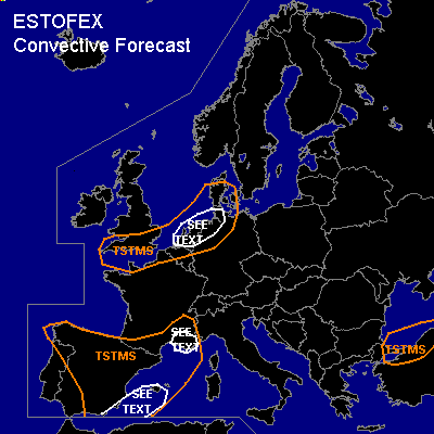
CONVECTIVE FORECAST
VALID Fri 04 Nov 06:00 - Sat 05 Nov 06:00 2005 (UTC)
ISSUED: 03 Nov 16:38 (UTC)
FORECASTER: TUSCHY
SYNOPSIS
Main feature of interest will be a highly amplified but also weakening trough over western Europe, which slowly drags northeastward during the next 24 hours... Looks like the compilation of this trough is underway, where strongest part will slide eastward over the English Channel, reaching N-Germany/Denmark during the night hours... Southern part of this system ( situated over Spain) will continue to weaken( consistently warming cloud tops west of Spain yesterday evening) under the influence of a strengthening high pressure area over the Azores, maintaining its positive tilt....Most parts of central Europe will feel the influence of ridging downstream of this trough....again.... Black Sea region will see the effect of strong UL cut-off low with unsettled weather.
DISCUSSION
...Spain, Balearic Sea and coastal areas of S-France...
Went with a pretty broad TSTM area, because of arriving and weakening UL trough... Pretty diffuse synoptic-forcing and locally enhanced topographically enhanced lift should produce isolated TSTMS over a broad area over Spain...Expect main time for development, when trough axis with pretty cold mid level airmass will cross Spain from west to east and some instability can be released, but weak kinematic parameters preclude any widespread storm organisation....main risk should be a marginal hail threat.
During the late afternoon/early evening hours, area of enhanced convection should develop along the NW African coast, moving offshore during the night hours....Models agree in enhanced UVV values and UL difluence ( strong right entrance region of jet), so isolated to scattered storms accepted...Thermodynamic environment not that good but some low-end SBCAPE is forecasted mainly over the open waters...DLS of 15-20m/s high enough for some storm organisation ...main risk will be a few severe wind gust reports.
Enhancing pressure gradient will help for strong onshore flow over SE France...Yesterday synop datas from this area [15UTC] showed continuous SE flow with up to 15kt and this should continue during the forecast period...Up to 400J/kg MLCAPE are forecasted, although highest values should be confined for the coastal areas...tongue of this instability also thin and a fast decay during the night hours forecasted...Expect scattered TSTM development especially in the SEE TEXT area....DLS up to 25m/s will enhance the severe wind gust risk...tornado threat will be marginal, because of displaced LL shear/instability tongue , but don't want to exclude a tornado along the coastal areas.
...south United Kingdom, English Channel, parts of Belgium,Netherlands,north Germany and Denmark...
Short wave trough will cross the English Channel during the afternoon hours, reaching NW Germany during the night hours...Isolated TSTM development expected when core of coldest mid-level airmass will finally reach the SEE TEXT area...weak windfield under the base of this system will diminish the severe weather risk, although there should be a marginal hail risk and again... don't want to exclude a waterspout along the coastal areas of NW Germany/Netherlands....threat too marginal for issuing a risk category.
#