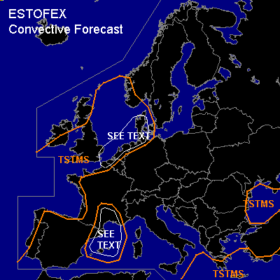

CONVECTIVE FORECAST
VALID Thu 03 Nov 06:00 - Fri 04 Nov 06:00 2005 (UTC)
ISSUED: 02 Nov 20:44 (UTC)
FORECASTER: GATZEN
SYNOPSIS
Upper ridge extends from northern Algeria to eastern central Europe and further to western Russia. To the east and west ... low geopotential is present over Turkey/Black Sea region and western Europe. While cold airmass is present over eastern Europe and spreads into eastern Mediterranean ... warm and moist airmass advects into central Europe, North Sea region, and southern Scandinavia.
DISCUSSION
...Northwestern Mediterranean and southern France
...
West European trough propagates eastward ... and upper trough axis will reach Iberian Peninsula during the period. To the east ... strong upper jet is expected to spread into western Mediterranean ... and embedded vort-maxima are forecast leading to QG forcing. At lower levels ... latest model output shows that relatively moist maritime airmass over western Mediterranean destabilizes ... and sufficient CAPE may form. Due to strong WAA and DCVA ... showers and thunderstorms are forecast to develop over western Mediterranean. As vertical wind shear is forecast in the range of 20+ m/s over southern France region ... thunderstorms are expected to be organized ... and multicells and embedded mesocyclones are forecast ... capable of producing large hail and severe wind gusts. Allover threat seems to be quite low. Intense precipitation and local flash flooding is expected to pose a significant threat over southern France.
...Southern North Sea
...
Moist and unstable airmass will be present over southern North Sea region. Aloft ... strong upper jet streak travels northeastward over Benelux, and northwestern Germany. Underneath the cyclonic flank ... DCVA / QG forcing should lead to showers and thunderstorms ... moving northeastward and spread into Denmark during the period. Near the coast ... relatively strong LLS and low LCL height should be favorable for a few tornadoes. Severe wind gusts should be also possible with any thunderstorm that forms. Allover threat seems to be too low for a SLGT ATTM.
#