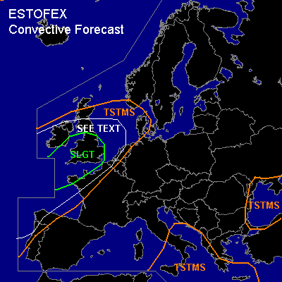

CONVECTIVE FORECAST
VALID Wed 02 Nov 06:00 - Thu 03 Nov 06:00 2005 (UTC)
ISSUED: 01 Nov 23:35 (UTC)
FORECASTER: GATZEN
There is a slight risk of severe thunderstorms forecast across southern British Isles
SYNOPSIS
While relatively low geopotential covers northeastern Atlantic ... upper ridge is present over western and central Mediterranean ... and is expected to ridge into high pressure system over northeastern Europe during the period. To the west ... strong and deep southwesterly flow affects western, northwestern, and northern Europe ... and several vort-maxima/short-wave troughs are forecast. To the east ... upper cut-off low should remain over Black Sea region. At the surface ... quite intense low propagates ENE-ward reaching southern Ireland at the end of the period. Warm and unstable maritime airmass spreads into British Isles east of associated cold front.
DISCUSSION
...British Isles, northwestern France, Channel region, Benelux, North Sea, Bay of Biscay, northwestern Iberian Peninsula
...
A intense surface low pressure system moves into southern Ireland during the period. To the east ... warm and very moist maritime airmass is expected to spread into northwestern France, and southern/central British Isles. Latest available models show that this airmass will be unstable ... with CAPE reaching several 100 J/kg and LI reaching -2 over a relatively broad region ... while soundings confirming this forecast are not available. If this scenario comes true and sufficient instability will form ... synoptic setup seems to be favorable for organized severe convection. DLS of 30 m/s and LLS of 12.5+ m/s is expected ... as well as rather strong veering and low-level helicity of more than 100 J/kg. During the day ... warm maritime airmass should spread into southern British Isles underneath an upper ridge moving northeastward quickly. In the afternoon/evening hours ... a strong short-wave trough/vort-max travels northeastward ... reaching southwestern British Isles around 15 UTC. Associated strong upper jet streak travels NNE-ward ... leaving southern and eastern British Isles underneath the right entry region ... where strong QG forcing is expected due to WAA and DCVA. At lower levels ... the surface cold front is forecast to move eastward ... crossing southern and central British Isles before Thursday, 00 UTC. Given strong QG forcing ... showers and thunderstorms are expected to form in the range of warm maritime airmass ... that will have a high potential to organize into multicells and supercells. As LLS and low LFC heights should be favorable for tornadoes ... a couple of events ... including a few strong events ... may be possible. Isolated large hail and severe wind gusts are also expected. However ... given uncertainty of instability ... later observations have to be awaited for a more detailed forecast. Convective activity should spread into northwestern France, The Channel region, Benelux, and North Sea later on. A few severe events should be possible given strong vertical wind shear. Allover threat seems to be lower than over southern British Isles. Further south ... rather strong vertical wind shear along the propagating cold front may be favorable for a few tornadoes, as well. Allover threat is expected to be too low for a SLGT ATTM.
#