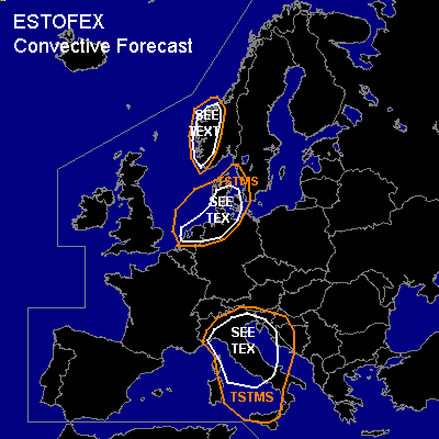
CONVECTIVE FORECAST
VALID Tue 01 Nov 08:00 - Wed 02 Nov 06:00 2005 (UTC)
ISSUED: 01 Nov 09:16 (UTC)
FORECASTER: TUSCHY
SYNOPSIS
Strong upper-level trough shifts northeastward along the eastern flank of an intense planetary wave, situated over the northern Atlantic ocean...Intense cyclogenesis on the way SW of Ireland (also seen on IR loop where a well developed warm front shield spreads eastward ATM)...Strong ridging over central Europe continues to weaken while moving towards the northeast, creating an high-over-low pressure field over eastern Europe...this cut-off low over SE Europe will be nearly stationary during the forecast period.
DISCUSSION
...Netherlands,northern Germany,Denmark and west coast of Sweden...
Time frame for some convection confined regarding the rapidly approaching warm front shield of the intense Antlantic cyclogenesis....However, trough axis with cold mid-level airmass will slide northeastward over the area of interest...Steepening LL lapse rates should provide some low-end instability to develop...Background flow with up to 20m/s pretty srong, which would be conducive for a few severe wind gusts and isolated large hail reports....despite the forecasted weak low level wind shear, there could be the chance for one or two tornadoes along mesoscale features along the coastline, given slight veering trend [ up to ~ 800hPa 00Z ] in the profilers, although threat will be too marginal for issuing a risk category.
...southwest Norway...
Same trough will also affect parts of SW Norway during the night hours and a few storms should develop, given some low-end instability values and quite a bit of forcing... Enhanced LL shear will pose a risk for one or two tornadoes and a few severe wind gusts, although TSTM development too isolated for introducing higher probabilities.
...Italy, Slovenia, Croatia and most parts of Bosnia and Herzegovina...
Weak LL surface cyclogenesis will shift eastward very slowly as a consequence thereof a weak cold front...Instability with up to 500J/kg looks reasonable and scattered to widespread TSTM development expected. All-over shear parameters very weak, despite one region....northern Italy is forecasted to be on the north side of eastward shifting depression and therefore, slightly backing wind field forecasted...This should locally enhance LL shear and one or two tornadoes will be possible.
#