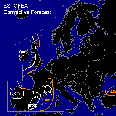
CONVECTIVE FORECAST
VALID Mon 31 Oct 06:00 - Tue 01 Oct 06:00 2005 (UTC)
ISSUED: 30 Oct 17:01 (UTC)
FORECASTER: TUSCHY
SYNOPSIS
An highly amplified / omega-like weather pattern continues during the forecast period, although a change is imminent... Intense cyclogenesis (about 1200 miles south of Greenland )and accompanying strong WAA helps to lift the impressive trough northeastward ( situated over Ireland and western Europe)....This constellation places most parts of southern and central Europe under a strong ridge,although ridge axis will also start to shift eastward very slowly...Most parts of SE Europe will be affected by a stationary upper-level cut-off...Main focus for convective development will be eastward moving and weakening frontal systems over western Europe.
DISCUSSION
...French Mediterranean coast...
Area will be affected by approach of upper-level trough axis... Departing and strengthening upper-level jet ( up to 130kt )will place the area of interest under the right rear entrance quadrant and high divergence values are forecasted over this region...Focus for initiation will be a weakening and slowly eastward propagating cold front, although there were signs during the past few runs, that parts of this frontal system could retreat westward as a consequence of a developing LL depression next to the SE French coast....Strength of this depression not very impressive....therefore, models don't forecast a backing wind field yet, but a strengthening confluent flow, which should also help for strengthening UVV values along decaying front...Finally, terrain favorable for topographically enhanced forcing and hence the confidence is high that at least scattered storms will develop...Strong onshore flow already present yesterday at 15UTC and MM5 forecasts persistent advection of higher PWAT values...Only inhibiting factor should be marginal instability... ATM I'll go with the model pool, which forecasts about 100-200 J/kg MLCAPE with locally higher values along the coast....This combination detaches best thermodynamic/kinematic parameters...Main risk will be a few severe wind gusts... Situation has to be monitored how far north cells will develop, because this would place them in a region of better LL shear and hence an enhanced tornado risk.
...southeast and east Spain...
During the early part of the forecast period, decaying and eastward moving cold front should pose a risk for some TSTMS...slightly enhanced LL shear and influx of moist Mediterranean airmass (low LCLs) should be enough for the cahnce for one or two tornadoes and a few severe wind gusts... Threat will diminish during the afternoon hours, when wind field relaxes.
...northwest Spain and north Portugal...
Arrival of upper-level trough axis with cooler mid level airmass should help for some TSTM development...LL shear slightly enhanced and there will be the risk for one or two tornadoes and severe wind gusts...This risk will be focused along decaying eastward moving cold front and although isolated storms should fire up till the evening hours, weakening wind field should help for a decreasing severe weather threat.
...Ireland and most parts of United Kingdom...
Upper-level depression and adjacent strong CAA helped to generate impressive mid level cold pool ( yesterday at 15 UTC area of enhanced convection was situated ~ 50N/15W ), which will move eastward during the forecast period, arriving over Ireland during the early afternoon hours...Downstream of this colder airmass, cold front will slide eastward over United Kingdom during the afternoon hours, providing some lift for isolated TSTM development...LL shear slightly enhanced and one or two tornadoes can't be ruled out, but again...front is forecast to weaken during the afternoon/evening hours and as a consequence thereof a decreasing wind field/severe weather threat...Further to the west over Ireland,forecast soundings show steepening mid-level lapse rates but also a weakening background flow ( when trough axis finally approaches)... Main risk will be an isolated large hail risk.
#