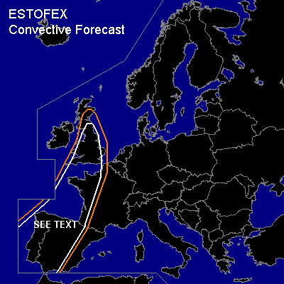

CONVECTIVE FORECAST
VALID Sun 30 Oct 06:00 - Mon 31 Oct 06:00 2005 (UTC)
ISSUED: 29 Oct 19:13 (UTC)
FORECASTER: DAHL
SYNOPSIS
Quite extensive ... stationary upper trough is covering the entire ERN Atlantic ... with several peripheral vort maxima at its E side sustaining large SFC low-pressure complex over the E Atlantic and the British Isles ... which is maintaining strong WAA regime over WRN parts of Europe. E Europe is affected by rather strong SFC high ... supporting dry/cold advection into the Balkans and Turkey. Quiescent conditions persisting across the Mediterranean. Best thermodynamic parameters this period (with MLCAPEs up to 1000 J/kg) seem to exist over the W Mediterranean ... but will likely remain capped through Sunday.
DISCUSSION
...Iberian Peninsula ... France ... British Isles...
It seems that the only chance of deep convection exists in weakly unstable/moist subtropical air mass over W parts of Europe. Models generate bulk of precip along wavy cold frontal boundary over Spain ... France and the British Isles. Most of this precip should be of non-convective nature ... though it appears likely that a few imbedded TSTMS will occur. 500 hPa flow of about 20 to 25 m/s and 850 hPa flow of 15 to 20 m/s should provide sufficient shear for any SFC-based deep convective cell that manages to form. Given low LCLs ... and minimal capping ... and minimal CAPE/saturated profiles ... main severe threat should be isolated/brief tornadoes. However ... current thinking is that TSTM activity will remain rather isolated ... limiting severe threat. A SLGT may be needed if convection happens to be more widespread than currently anticipated.
#