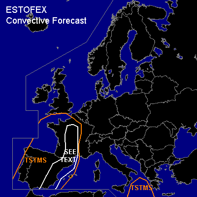

CONVECTIVE FORECAST
VALID Sat 29 Oct 07:00 - Sun 30 Oct 06:00 2005 (UTC)
ISSUED: 29 Oct 07:34 (UTC)
FORECASTER: DAHL
SYNOPSIS
High amplitude upper flow pattern is present across Europe ... with large-scale upper ridge covering central and NRN/NERN Europe ... an upper low over SE Europe over the Black-Sea region ... and an extensive upper trough over the E Atlantic. Vort max embedded in the W periphery of the upper ridge is progged move across France on Saturday. At the SFC ... WAA continues across W Europe E of the Atlantic low-pressure complex ... while high pressure persists over E parts of Europe.
DISCUSSION
...France ... Iberian Peninsula...
Degree of CAPE in the warm/moist air mass over France and Spain remains uncertain ... but it seems that peak CAPE values of about 1000 J/kg may be realized where mean-layer mixing ratios of about 13 g/kg and some SFC heating can be realized. However ... air mass will likely be capped under an EML plume that is apparent over the SW Mediterranean and E Spain. Farther N over France ... profiles tend to be more neutrally stratified ... with accordingly less CAPE ... and less capping. Towards the evening ... another plume of subtropical/Atlantic air will reach W Iberia and the British Isles ... wich may also contain weak instability per model guidance ... though shape of the themodynamic profiles and degree of CAPE is uncertain ... but unlikely to be very substantial.
Deep shear of about 20 to 25 m/s and low-level shear in excess of 10 m/s over France should provide favorable kinematic environment for a few severe TSTMS. Shear should be somewhat weaker towards the SW over Iberia ... but may still be supportive of isolated severe evolution.
Main focus for convective development should be the short-wave trough which is to cross France today ... and another vort max expected to overspread the Iberian Peninsula late in the period. Expect scattered TSTMS over France and over E Spain in the afternoon/evening hours ... which may produce a few strong/severe wind/hail events ... and also a tornado or two given strong LLS. Weak thermodynamic support currently precludes introduction of a SLGT ... though an upgrade may be needed later today.
TSTMS over E Spain should be more isolated owing to stronger capping/lesser large-scale forcing for UVVs. An isolated severe wind/hail event may occur though ... but threat should be lower than farther N over France.
Isolated TSTMS may occur across W Iberia ... the Gulf of Biscay into the S UK late in the period ... these should mainly be of elevated nature ... and pose minimal severe threat.
#