CONVECTIVE FORECAST
VALID Fri 28 Oct 06:00 - Sat 29 Oct 06:00 2005 (UTC)
ISSUED: 27 Oct 16:34 (UTC)
FORECASTER: TUSCHY
SYNOPSIS
Highly amplified weather pattern ongoing during the next 24 hours....Impressive longwave trough present over eastern Atlantic Ocean/parts of western Europe, even reaching NW Africa...Downstream of this system, unseasonable strong WAA ( up to latitude 70N )covers most parts of southern and central Europe, where warm and stable condition can be expected. Typical of an omega-like weather pattern, strong CAA develops east of this ridge, covering most parts of eastern Europe.
DISCUSSION
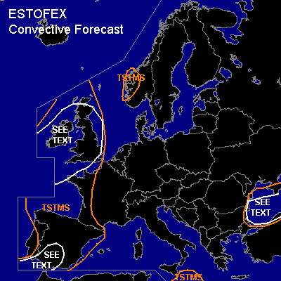
...most parts of Spain and extreme southwestern France...
First focus for some storm development will be slowly eastward moving cold front during the morning/noon hours....Yesterday SFLOC datas showed nice activity along the front SW of Spain and current thinking is that this instability can be adveced well inland over most parts of southern and central Spain...Models forecast a narrow and weak instability tongue along the front and forcing of front + locally topographically enhanced forcing should be enough for a few TSTMS to develop...Background-flow up to 20m/s combined with enhanced LL shear ( locally 17m/s+) would pose a risk for a few severe wind gusts...Basically, the best area for a few tornadoes should be the coastal areas of southern Spain, where low LCLs and highest instability values will be present, but also expect one or two tornadoes well inland, regarding the strong kinematic parameters... Don't want to issue a SLGT ATM, beause of some negative factors, like models trend of pretty fast decaying instability tongue and weakening forcing along eastward shifting cold front ( as a consequence of a parallel alignment at the background flow and the arrival of another weak trough axis during the early afternoon hours over NW Spain ).
Next round of convection development will be during the afternoon hours over NW Spain, when trough axis with cooler mid-level airmass and additional forcing should help for some storm development... Again, LL shear enhanced ( up to 17m/s ) and a few severe wind gusts and one or two tornadoes should develop, although threat too marginal for issuing a risk category.
...northwestern France,United Kingdom and Ireland...
After the passage of northeastward moving cold front during the early morning hours, conditions look favorable for a few postfrontal storms...Synoptic pattern complex, because of a few factors, which could affect the TSTM forecast for this area... Weak trough should cross the SEE TEXT area during the late afternoon/early evening hours (SW-NE), where you can expect the best chance for a few storms to develop... Kinematic parameters high enough for storm organisation and there will be the risk for a few severe wind gusts and tornadoes...especially, when a line of storms can form.
After the passage of this trough line, NVA and strengthening WAA of another developing depression further to the west should steadily suppress convection development from SW toward the NE ( in fact, IR loop 15UTC showed warm convection tops at longitude ~12W as a consequence of this WAA).
...Black Sea...
Southward amplifying upper-level trough will reach the Black Sea area during the noon hours... A steady cool down of the mid-levels and steep LL lapse rates over the 15-17°C warm water should help for the development of some low-end instability...weak windfield under the base of the trough should suppress widespread storm organisation, although a threat for a few waterspouts will exist.
#