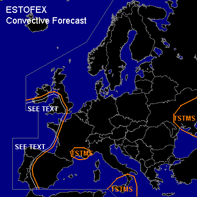

CONVECTIVE FORECAST
VALID Thu 27 Oct 08:00 - Fri 28 Oct 06:00 2005 (UTC)
ISSUED: 27 Oct 07:54 (UTC)
FORECASTER: GATZEN
SYNOPSIS
Impressive meridional weather pattern builds over Europe ... with an amplified long wave trough reaching from Iceland to Canary Isles. At the eastern flank of this trough ... deep southerly flow transports very warm airmass originating from Atlas mountains into northwestern Europe. Latest soundings show 850 hPa temperatures up to 20°C over Bay of Biscay, and latest GFS model run expects 15°C in this level over northern North Sea during the day. This airmass is characterized by an elevated mixed layer reaching from 800 to 550 hPa. Below this level ... relatively warm and quite moist airmass is present over parts of western Europe ... yielding low CAPE underneath the inversion as indicated ba latest Nimes sounding ... and weak showers and thunderstorms may form today due to QF forcing in the WAA regime. During the period ... strong WAA supports a high pressure system from central Mediterranean to central Scandinavia. Over western Europe ... slowly propagating cold front is expected to reach Iberian Peninsula and British Isles. West of the cold front ... convectively mixed maritime airmass spreads eastward.
DISCUSSION
...Southwestern Iberian Peninsula
...
Ahead of propagating cold front ... moist and unstable subtropical airmass spreads northward ... reaching southwestern Iberian Peninsula during the day. As thunderstorms have already formed along propagating cold front over eastern Atlantic ... it is expected that thunderstorms should spread northward into Iberian Peninsula. Current thinking is that most of the storms will be elevated ... as low level airmass is quite dry and cool. However ... surface-based storms are not ruled out given quite moist maritime airmass spreading northward. Given strong vertical wind shear just east of the propagating cold front ... storms may be well-organized ... and mesocyclones/multicells are expected ... capable of producing isolated large hail and severe wind gusts. The potential for tornadoes is unclear ATTM ... due to uncertainty of low level CAPE/moisture. Given strong LLS along the front ... chance for tornadoes seems to be enhanced ... and a few events are forecast. An upgrade to SLGT may be warrant when thunderstorms will be more intense as expected.
...Western Iberian Peninsula, western Bay of Biscay, southwestern British Isles
...
Convectively mixed maritime airmass spreads eastward in the wake of the cold front ... and should affect mentioned region. Showers and thunderstorms are expected to form. Given strong vertical wind shear ... risk for severe wind gusts and a few tornadoes should be enhanced ... and a few events are forecast. Allover threat should be relatively low ... and a SLGT seems to be not warrant ATTM.
#