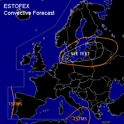

CONVECTIVE FORECAST
VALID Wed 26 Oct 06:00 - Thu 27 Oct 06:00 2005 (UTC)
ISSUED: 25 Oct 21:08 (UTC)
FORECASTER: GATZEN
SYNOPSIS
Upper long-wave ridge over Mediterranean/central Europe remains. Over Germany/Poland ... a short-wave trough centered over Scandinavia slides under the upper ridge and is expected to amplify as it propagates eastward. To the west ... amplified upper long-wave trough over eastern Atlantic leads to strong WAA over western Europe ... building another ridge over North Sea/southern Scandinavia region. As a consequence ... large scale descend and WAA aloft leads to stabilization over most of western, central, and northern Europe. Unstable airmass is expected in the range of the eastward moving short-wave trough over Baltic Sea region, as well as over south-central Mediterranean in the range of ill-defined upper cut-off low.
DISCUSSION
...Southern Baltic Sea region, Baltic States, extremely western Russia, northern Belarus
...
Maritime airmass characterized by neutral lapse rates is present from North Sea to Baltic Sea region. This airmass is expected to destabilize in the range of the upper short-wave trough due to QG forcing and low-level heating over relatively warm sea surface ... and showers and thunderstorms are forecast to go on over southern Baltic Sea region ... spreading into Baltic States, western Russia, and northern Belarus. Although amount of instability is forecast to decrease east of the Baltic Sea ... convection may be well-organized as vertical wind shear will be quite strong. Strong DLS of more than 20 m/s indicated by latest GFS model run is expected over southern Baltic Sea region ... and multicells and bowing lines capable of producing severe wind gusts should be possible. Strong LLS is forecast at the southern flank of the surface low pressure system ... where strong pressure gradient and friction over land create quite high helicity values ... and a few mesocyclones capable of producing severe wind gusts, possibly tornadoes, and isolated large hail may form. Allover threat should be significantly lower as on Tuesday ... as models indicate decreasing instability. Convective activity is forecast to decrease in the evening hours.
...South-central Mediterranean
...
Mediterranean airmass characterized by steep lapse rates, quite high CIN and rather poor boundary layer moisture will be present at the northern flank of weak upper cut-off over southern Mediterranean/northern Africa. Thunderstorms are expected along low-level convergence lines/boundaries. Weak vertical wind shear, weak forcing, and quite high CIN should limit severe threat.
#