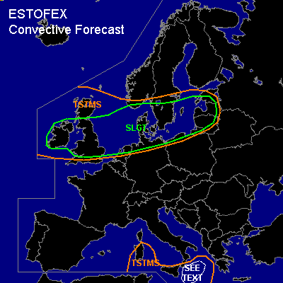

CONVECTIVE FORECAST
VALID Tue 25 Oct 06:00 - Wed 26 Oct 06:00 2005 (UTC)
ISSUED: 25 Oct 01:10 (UTC)
FORECASTER: VAN DER VELDE
There is a slight risk of severe thunderstorms forecast across The British Isles, northern Netherlands Germany and Poland, Denmark, the Baltic States, southern Sweden and extr. southern Norway
SYNOPSIS
An already mature low pressure area centered over Scotland is accompanied by tight horizontal pressure gradients that generate strong winds. Behind the cold front, a 300 hPa (north)westerly jet maximum of >70 m/s and its left exit region into an upper shortwave trough will focus dynamic lift and deep-layer shear mostly over the central parts of the British Isles (morning and evening), the northern Netherlands (noon), northern Germany and southern Denmark (afternoon), northern Poland and finally Lithuania (night/early morning).
GFS 12Z shows a pool of cold upper air and deep instability sufficient for thunder following behind the cold front and near the core of the low. Precip and vorticity in NMM 12Z suggest a comma cloud affecting Denmark during the night after the earlier postfrontal convection.
DISCUSSION
...SLGT area...
Apart from overall windy conditions with occasionally severe gusts especially in coastal areas, significant contribution to severe gusts will come from convective features. As we go by winds forecast in the lowest kilometers above ground, some 25-30 m/s gusts can be caused in combination with storm downdrafts over a wide region. The largest chance of organized convective development will be focused in the overlap zone of the jet stream and instability (up to a few 100 J/kg CAPE), i.e. the southern parts of the SLGT area.
As both GFS and NMM indicate instability following right after the cold front, with even a linear enhancement, expect that a narrow zone of convection at the front is likely in the form of a squall line, especially over the southern UK and Benelux where sea water temperatures of >16C add some heat into the boundary layer.
Shear conditions will be very favorable throughout the SLGT region to promote updraft rotation. Strong low-level wind fields create not only potential for severe gusts, but in combination with friction over land, 0-1 km shear vectors will be enhanced to over 15-20 m/s, creating favourable conditions for tornadoes along with the low LFC heights (<1000m). This is also indicated by SREH >100-200 m2/s2, due to clockwise turning wind profiles close to the ground. Deep layer (0-6 km) shear vectors amount over 35 m/s, and still a high 25 m/s expected over southern Scandinavia.
Overall, expect a number of (F0-F2) tornadoes, damaging gusts, and some isolated large hail events.
...southern Mediterranean...
Modestly enhanced deep layer shear, SREH and convergence near a shallow low pressure area in an airmass with steep lapse rates, but marginal moisture content, suggest some chance of severe weather (large hail, strong outflow due to dry air aloft) if a storm manages to develop. However, GFS isn't very positive about convective precipitation developing in the region.
#