CONVECTIVE FORECAST
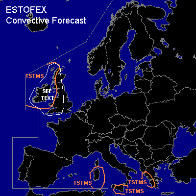
VALID Mon 24 Oct 06:00 - Tue 25 Oct 06:00 2005 (UTC)
ISSUED: 24 Oct 08:27 (UTC)
FORECASTER: GROENEMEIJER
SYNOPSIS
Monday at 12 UTC... a weakly meandering flow is expected in the mid-troposphere with a trough located from eastern Finland to the eastern Balkans, a ridge from south-central France to the Norwegian Sea and a closed low with an associated longwave trough about 800 km west of Ireland. Patches of unstable are air located over the central Mediterranean and may cause some local, likely nosevere storms over Sardinia and Sicily and western Greece.
DISCUSSION
...British Isles...
As the aforementioned low west of Ireland moves eastward, a cyclonically-curved jet streak on its southern flank intensifies, while a baroclinic low develops, that has large amounts of shear in its warm sector.
Although the formation of convective rainbands along such a system's cold front are hard to predict, indications are that convective instability will not form within the warm sector and severe storm potential should be low there. Some postfrontal deep convection is likely to form, but the amount of instability will likely be very small until around midnight, when a deeper unstable layer is forecast to move in from the west ahead of a shortwave trough. The chance of thunder will then increase and, since low-level wind speeds should be rather strong, a couple of strong, but mostly non-severe (<25 m/s) gusts are likely.
#