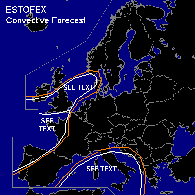

CONVECTIVE FORECAST
VALID Fri 21 Oct 06:00 - Sat 22 Oct 06:00 2005 (UTC)
ISSUED: 20 Oct 22:13 (UTC)
FORECASTER: DAHL
SYNOPSIS
Vort max ejecting from upper low centered over the N British Isles on Thursday 12Z will track across the Baltic States into NW Russia during the period ... with rather intense upstream vort max crossing the S British Isles ... moving into the North Sea by Saturday 06Z. Weak vort maxima imbedded in broad SWLY upper flow will affect the the W and central Mediterranean. Two relatively intense SFC low centers are expected to develop ahead of the aforementioned - British and Baltic - vort maxima ... maintaining extensive ... elongated SFC low stretching from the Gulf of Biskay into N Scandinavia ... which will advect moist subtropical/Atlantic air into SW and central Europe on Friday.
DISCUSSION
...S UK ... North Sea...
SFC low is expected to cross the S UK during the first half of the period. A few TSTMS have already formed along trailing cold front on Thursday evening ... and expect convective activity to persist/increase as SFC low deepens. LL and DL shear should be sufficient for rotating updrafts ... though convection may be rather shallow and not strongly electrified. However ... a few tornadoes may well occur with this activity ... along with marginally severe hail and damaging stright-line winds. Uncertainty on the coverage precludes a SLGT ATTM.
...central Mediterranean...
Elongated vort max should cross the WRN Mediterranean on Friday ... which should support convection along SFC convergence over the central Mediterranean. Though CAPE should be quite weak ... it seems that low LCLs will be in place along with weak CINH. Also ... LLS of 10 m/s ... increasing towards the evening should be available. This suggests that a few tornadoes may occur. Lack of strong deep shear and weak thermodynamic parameters preclude a more emphatic outlook ATTM.
...SW and central Europe...
Models advertise weak CAPE in the subtropical air masses spreading across SW and central Europe ... with the clearest signals over the Gulf of Biskay/W France and the W Iberian Peninsula. Deep shear of about 20 m/s ... and LL shear of 10 to 20 m/s over central and SW Europe, respectively, suggest that some severe potential exists ... if SFC-based convection manages to form. It seems that best chances for TSTMS exist over W France and W Iberia late in the period ... though an isolated/brief TSTM cannot be excluded over central portions of Europe ... especially during the afternoon hours. Situation will need to be monitored for possible upgrades over central Europe once the morphology of the thermodynamic profiles becomes clearer.
#