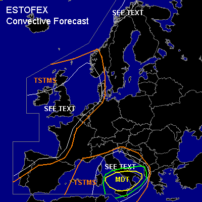

CONVECTIVE FORECAST
VALID Thu 20 Oct 15:00 - Fri 21 Oct 06:00 2005 (UTC)
ISSUED: 20 Oct 14:37 (UTC)
FORECASTER: GATZEN
There is a moderate risk of severe thunderstorms forecast across southern Italy region
There is a slight risk of severe thunderstorms forecast across central Mediterranean
There is a moderate risk of severe thunderstorms forecast across
SYNOPSIS
Between two high pressure systems over Greenland and eastern Europe ... low geopotential is present from eastern Atlantic to British Isles, northern North Sea, and northern Scandinavia. At the southeastern flank of this upper trough ... several vort-maxima travel northeastward affecting southwestern, western, and northern Europe. At the northwestern flank ... cold arctic airmass starts to spread into northwestern Scandinavia. Over the Mediterranean ... rather deep southwesterly flow will remain east of low geopotential over eastern Atlantic ... and warm airmass spreads northeastward over western and central Mediterranean, central, and eastern Europe.
DISCUSSION
...Southern Italy region...
Warm airmass originating from the Atlas mountains remains over western and central Mediterranean ... indicated by latest soundings showing steep mid-level lapse rates. In the boundary layer ... low-level moisture has decreased by a few g/kg mixing ratio ... but latest GFS model run suggests that instability will increase during the forecast period again. Aloft ... weakening upper short-wave trough is expected to travel northeastward reaching Adriatic Sea on Thursday. QG forcing is expected in the range of this upper trough ... and given quite strong instability and weak CIN ... convective activity is expected to go on over western central Mediterranean. At the southern base of the upper trough ... strong DLS is forecast ... and thunderstorms that formed have merged into a few MCS slowly moving eastward.
Latest sounding information indicates a thermodynamic environment favorable for tornadic supercells ... with strong (15 m/s) LLS, low (500 m AGL) LFC heights and CAPE up to 800 J/kg (Pratica di Mare). Expect that this environment will remain during the next couple of hours ... while QG forcing in the range of the upper trough should remain as well ... and convective activity should go on ... while chance for (embedded) tornadic supercells seems to be quite high. A couple of events ... including one or two strong tornadoes ... is forecast.
Thunderstorms are expected to spread into Adriatic region later on. To the west ... weak upper ridge should lead to QG sinking ... and chance for severe thunderstorms should be relatively low.
#