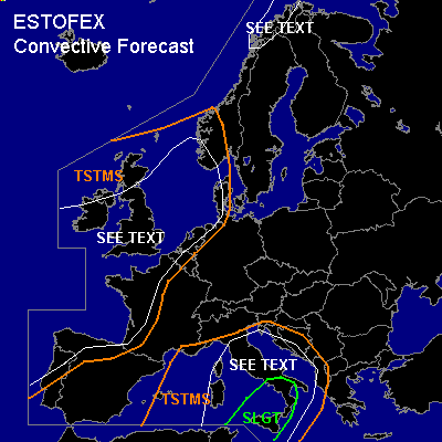

CONVECTIVE FORECAST
VALID Thu 20 Oct 06:00 - Fri 21 Oct 06:00 2005 (UTC)
ISSUED: 19 Oct 20:15 (UTC)
FORECASTER: GATZEN
There is a slight risk of severe thunderstorms forecast across western central Mediterranean, Italy
SYNOPSIS
Between two high pressure systems over Greenland and eastern Europe ... low geopotential is present from eastern Atlantic to British Isles, northern North Sea, and northern Scandinavia. At the southeastern flank of this upper trough ... several vort-maxima travel northeastward affecting southwestern, western, and northern Europe. At the northwestern flank ... cold arctic airmass starts to spread into northwestern Scandinavia. Over the Mediterranean ... rather deep southwesterly flow will remain east of low geopotential over eastern Atlantic ... and warm airmass spreads northeastward over western and central Mediterranean, central, and eastern Europe.
DISCUSSION
...Western and central Mediterranean
...
Warm airmass originating from the Atlas mountains remains over western and central Mediterranean ... indicated by latest soundings showing steep mid-level lapse rates. In the boundary layer ... low-level moisture has decreased by a few g/kg mixing ratio ... but latest GFS model run suggests that instability will increase during the forecast period again. Aloft ... weakening upper short-wave trough is expected to travel northeastward reaching Adriatic Sea on Thursday. QG forcing is expected in the range of this upper trough ... and given quite strong instability and weak CIN ... convective activity is expected to go on over western central Mediterranean. At the southern base of the upper trough ... strong DLS is forecast ... and thunderstorms should likely organize into a few MCS propagating eastward affecting southern and central Italy. Severe wind gusts should be the main threat, but an isolated hail/tornado event is not ruled out completely. Intense rain and local flash flooding will be also a significant threat over most of Italy. Thunderstorms are expected to spread into Adriatic region later on. To the west ... weak upper ridge should lead to QG sinking ... and chance for severe thunderstorms should be relatively low.
...Western Europe
...
Several vort-maxima travel northeastward with quite strong southwesterly jet ... leading to QG forcing. Affected cold maritime airmass is convetively mixed as indicated by latest ascends ... and showers and thunderstorms will likely form. Moderate to strong vertical wind shear will be present, and thunderstorms may organize into bowing lines/ mesocyclones ... capable of producing severe wind gusts, isolated tornadoes and large hail. Allover threat will be quite low over a large region ... and a SLGT seems to be not warrant ATTM. Over northwestern Norway region ... arctic airmass is expected to destabilize over the sea surface and showers should form, capable of producing severe wind gusts. A few lightning strikes are not ruled out.
#