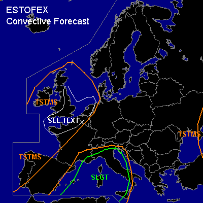

CONVECTIVE FORECAST
VALID Wed 19 Oct 06:00 - Thu 20 Oct 06:00 2005 (UTC)
ISSUED: 18 Oct 22:47 (UTC)
FORECASTER: GATZEN
There is a slight risk of severe thunderstorms forecast across western Mediterranean
SYNOPSIS
Upper high over central Mediterranean ridges into central Europe and further into northern North Sea, Iceland, and Greenland. South of the upper ridge ... well-developed trough placed over eastern Atlantic Ocean propagates northward over British Isles ... connecting to the frontal zone over northeastern Atlantic later on. Strong upper vort-max rotating around the base of this trough will affect northwestern Europe during the period. Over western Mediterranean ... deep southwesterly flow west of the upper ridge ... with quite strong upper short-wave trough present over northern Morocco moving northeastward ... should be focus of severe convective activity. Eastern Europe will be affected by amplified upper trough.
DISCUSSION
...Western Mediterranean
...
Strong upper short-wave trough present over northwestern Africa travels northeastward crossing western and northwestern Mediterranean ... and reaching northern Italy by the end of the period. Strong DCVA is expected at the northeastern flank of this upper vort-max. At lower levels ... warm airmass characterized by steep lapse rates between the 850 and 650 hPa level ... originating from African Atlas mountains advects northward into western and central Mediterranean ... where rich boundary layer moisture has built underneath the inversion. Latest Palma De Mallorca sounding shows nearly 15 g/kg mixing ratio in the lowest 100 hPa ... yielding CAPE of 1800 J/kg. On Wednesday ... models show that unstable airmass will remain over western Mediterranean east of propagating upper trough and associated cold front reaching Balearic Islands in the evening hours. Strong QG forcing is forecast by latest model output ... and thunderstorms are forecast to form. Although latest model output does not indicate strong vertical wind shear over western Mediterranean ... showing around 15 m/s DLS and weak LLS ... quite strong upper level jet is expected while southerly to southeasterly low-level winds should be present ... and vertical wind shear may be quite strong. Expect that thunderstorms will merge into mesoscale systems ... especially over northwestern Mediterranean ... moving ENE-ward into southern France, and northern Italy. Main severe threat will be straight line winds ... but isolated large hail and a tornado or two are not ruled out. Intense precipitation and local flash flooding is expected over southern France, and northern Italy ... posing a significant threat as well. Thunderstorms are expected to go on during the night and morning hours.
...The Channel region, southern British Isles, northern France, North Sea region
...
Strong upper short-wave trough rotating around the periphery of eastern Atlantic trough travels over northwestern Europe ... reaching southern North Sea on Thursday morning. Strong DCVA is expected to affect northern France, southern British Isles, Benelux, and southern North Sea region. At lower levels ... tongue of relatively warm, convectively mixed airmass originating from Bay of Biscay advects northeastward into eastern British Isles, and North Sea region. Latest Brest sounding indicates 10 g/kg low-level mixing ratio and steep low-level lapse rates. On Wednesday ... showers and thunderstorms are forecast to form in the range of this airmass ... affecting the Channel region, southern British Isles, and North Sea region. While vertical wind shear will be quite low in the range of the trough's center ... 20+ m/s DLS is forecast to be present at the edge of the vort-max ... and thunderstorms should be able to organize into bowing lines, and mesocyclones ... capable of producing severe wind gusts and isolated large hail. Given also enhanced low-level vertical wind shear near coastal regions, and low LCL heights ... chance for tornadoes will be enhanced, and a few events should be possible. Allover threat seems to be relatively high ... and an upgrade to SLGT my be warrant later on.
#