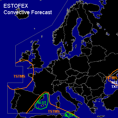

CONVECTIVE FORECAST
VALID Tue 18 Oct 06:00 - Wed 19 Oct 06:00 2005 (UTC)
ISSUED: 18 Oct 00:53 (UTC)
FORECASTER: VAN DER VELDE
There is a slight risk of severe thunderstorms forecast across the western Mediterranean Sea
There is a slight risk of severe thunderstorms forecast across Sicily/Malta
SYNOPSIS
A blocked omega flow pattern is in place with a high pressure area over Scandinavia and (upper) low pressure areas over the Romania/Black Sea and southwest of the British Isles. Thermal boundaries are found from Spain to the UK as a cold front, and over Italy and Greece where cold continental air flows southward. Instability is mainly present near the cold low cores, and in the thermal trough east of the Spanish cold front over the western Mediterranean, and the southern Mediterranean Sea, where fairly steep low-mid-level lapse rates are present.
DISCUSSION
...western Mediterranean Sea...
GFS 18Z modelrun and NMM 12Z indicate a few hundred J/kg MLCAPE and both low-level convergence and dynamical ascending motions. Mon 12Z Palma de Mallorca sounding showed already steep middle lapse rates and ample boundary layer moisture. With GFS also depicting strong deep-layer shear (>30 m/s) and enhanced SR helicity >200 m2/s2 (strong winds were also present in Mon 12Z soundings over Spain), organized, long-lived storms seem likely. A few may develop rotating updrafts which enhanced the probability of large hail, and a tornado or waterspout is not ruled out.
...southern Mediterranean Sea (Malta/Sicily)...
Brief thunderous convection has fired in this region on Monday, which highlights the chance of new development today, with at most a few hundred J/kg CAPE present. Models do generate very favorable wind shear conditions, such as >25 m/s 0-6 km shear, and >200 m2/s2 SREH over the lowest 3 km. Since indicated precip amounts are sketchy, assume not a great number of storms, but those that do form might become supercells with a threat of large hail and possibly a tornado.
...Black Sea area...
As a cold, unstably stratified airmass flows over the warm Black Sea, superadiabatic lower lapse rates and strong low level buoyancy can be created (like Mon 12Z Istanbul sounding), favouring the spin-up of vertical vorticity, especially near lines over convergent and calm low level winds.
#