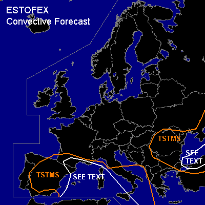

CONVECTIVE FORECAST
VALID Fri 14 Oct 06:00 - Sat 15 Oct 06:00 2005 (UTC)
ISSUED: 14 Oct 06:11 (UTC)
FORECASTER: DAHL
SYNOPSIS
Omega-type upper flow pattern is progged to establish over Europe late in the period ... with a building upper high spreading from the E Atlantic into central Europe ... and two upper lows over the Iberian Peninsula and SE Europe, respectively. Another upper low is present over N Scandinavia ... making little eastward progress through the period. At the SFC ... high pressure area should build over the Norwegian Sea and the North Sea ... extending across central Europe SWD into the N Mediterranean/Balkans. Strong SFC low ... moving into NE Europe/NW Russia until Saturday morning is accompanying the Scandinavian upper low.
DISCUSSION
...WRN Mediterranean...
Iberian upper low will likely continue to favor convective development beneath its center over Spain ... and in weakly unstable warm/moist air at its E and N periphery. Though thermodynamic profiles are rather weak ... deep shear on the order of 20 to 25 m/s should aid in local severe evolution ... main threats being marginally severe wind/hail. Also ... a tornado ot two may occur given little capping ... low LCLs and increasing LLS over the W Mediterranean and S France. Farther E ... DLS should decrease in greater distance to the upper low ... but low-level thermodynamic fields remain favorable for a few waterspouts.
...S Black Sea region...
Scattered TSTMS should continue to develop over the S-Black Sea region. Much of the current activity appears to be elevated and associated with low-level WAA. However ... 00Z ascents from N Turkey indicate that SFC-based instability is available as well. Though shear should be marginal ... an isolated/brief severe TSTM event could occur ... including the possibility of a brief tornado especially over the southern Black Sea region where shear profiles should be best (albeit still marginal).
#