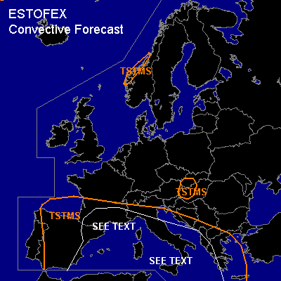

CONVECTIVE FORECAST
VALID Thu 13 Oct 06:00 - Fri 14 Oct 06:00 2005 (UTC)
ISSUED: 12 Oct 22:30 (UTC)
FORECASTER: GATZEN
SYNOPSIS
While blocking high over western Russia moves eastward ... upper trough at its southern flank over the Balkans remains quasistationary. Over western Europe ... sharp trough west of Iberian Peninsula cuts off ... and new high pressure system strengthens over southern North Sea. At lower levels ... a cold front crosses British Isles, North Sea region, and western/northern Scandinavia during the period ... replacing warm and moist airmass. To the south ... easterly winds at the northern flank of Iberian cut-off low advect moist and unstable airmass westward into France, and into Bay of Biscay again. Over the Mediterranean ... unstable airmass is expected to remain.
DISCUSSION
...Southern France, northwestern Mediterranean
...
At the northern flank of building cut-off low over Iberian Peninsula ... warm and very moist airmass originating from tropical storm Vince is advected northwestward into France. Aloft ... quite strong vort-max/short-wave trough moves northward reaching southern France on late Thursday. Strong WAA and quite strong DCVA should result in strong QG forcing ... and given very moist airmass and weak instability ... showers and thunderstorms are forecast. Strong (20+ m/s) DLS is expected by latest GFS model run ... and convection may merge into one or two MCS's over northwestern Mediterranean ... capable of producing isolated large hail, severe wind gusts and possible a tornado. However ... main threat will be intense precip and associated flash flooding over southern France.
...Western Mediterranean
...
Cold front of building cut-off low over Iberian Peninsula will cross parts of western Mediterranean on Thursday. East of the cold front ... warm and unstable airmass will be present ... characterized be rich low-level moisture and neutral to slightly unstable lapse rates. Weak QG forcing underneath approaching jet streak at the eastern flank of the cut-off low ... as well as low-level convergence along and east of the cold front should be strong enough to initiate showers and thunderstorms. While DLS in the range of the upper jet streak should remain west of the cold front ... amount of vertical wind shear should be quite weak to the east ... and chance for organized thunderstorms should be quite low. An isolated event is not ruled out, though.
...Central Mediterranean
...
Unstable airmass over Mediterranean remains. Quite steep low-level lapse rates and relatively rich low-level moisture ... as well as weak vertical wind shear over most places may be favorable for a few waterspouts. Allover threat seems to be lower than Wednesday.
#