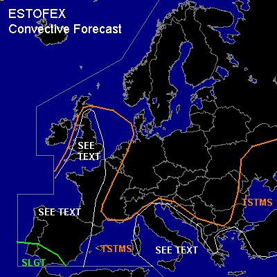

CONVECTIVE FORECAST
VALID Wed 12 Oct 07:00 - Thu 13 Oct 06:00 2005 (UTC)
ISSUED: 12 Oct 07:15 (UTC)
FORECASTER: GATZEN
There is a slight risk of severe thunderstorms forecast across southern Iberian Peninsula
SYNOPSIS
Well-developed high over low blocking dominates Europe again ... but the center of high geopotential is forecast to move eastward during the period, while upper cut-off low over Black Sea region/ Balkans slowly shifts westward at its southern flank. To the west ... a ridge is present from Morocco to Germany east of a long-wave trough over northern Atlantic Ocean. As a consequence ... a deep SSWerly flow is present from SWrn Iberian Peninsula to British Isles, northern Scandinavia, and further to northwestern Russia ... with a strong upper jet reaching 160 kts NW of Scandinavia. At lower levels ... a relatively narrow tongue of high equivalent potential temperature has spread northeastward ... and theta-e values of more than 40 °C are present over the southern Arctic Sea / northwestern Russia and northern Scandinavia, theta-e values up to 50 °C have reached British Isles ... and theta-e values of more than 50 °C originating from disappeared storm Vince are covering Iberian Peninsula and Bay of Biscay. Over the Mediterranean/ Black Sea region ... cold airmass has destabilized over the warm sea surface.
DISCUSSION
...Iberian Peninsula
...
Strong upper short-wave trough/vort-max is expected to spread eastward into Iberian Peninsula ... and strong upper jet streak should reach southern Iberian Peninsula. At lower levels ... a cold front propagates eastward over Iberian Peninsula during the period ... reaching SWrn Mediterranean on early Thursday. Warm and moist airmass east of the cold front is expected to be unstable ... and showers and thunderstorms will likely form during the day. Ahead of the cold front ... models indicate strong vertical wind shear over southern Iberian Peninsula ... reaching 10+ m/s LLS and 30+ m/s DLS ... and thunderstorms that form should be well-organized. Multicells, bowing lines and supercells may form ... capable of producing large hail, severe wind gusts, and probably a tornado or two. Intense precip/flash flooding will be also possible. However ... amount of instability is unclear ATTM ... as low-level moisture may be quite low over southern Iberian Peninsula ... limiting the threat for severe convection. To the northwest ... convectively mixed maritime airmass in the range of propagating short-wave trough should be unstable ... and thunderstorms are expected. Weak vertical wind shear is forecast ... and a few waterspouts may form.
...British Isles, Channel region, northwestern France
...
Tongue of very moist airmass over Bay of Biscay is expected to spread into southern/ eastern British Isles, and northern France today. This airmass is characterized by low-level mixing ratios of 10+ g/kg, neutral to unstable lapse rates and low LFC / LCL as indicated by latest soundings over Bay of Biscay region and southern British Isles. Latest surface observations indicate dewpoints up to 16 °C over southern British Isles at 06 UTC. A frontal boundary is present east of Ireland/ Scotland that is forecast to propagate southeastward during the period ... while strong upper jet over western British Isles is not expected to spread eastward. However ... strong WAA and at least weak DCVA should be present over British Isles ... where QG forcing may be quite strong today. Stratiform rain and embedded showers are forecast along and east of the frontal boundary. A few thunderstorms are not ruled out. Given relatively strong low level wind shear ... reaching more than 10 m/s over a broad region over southern/eastern British Isles ... as well as low level CAPE expected by latest model output ... airmass seems to be favorable for tornadoes ... and a couple of events is forecast. Intense precip/ flash flooding is also expected. Over France ... QG forcing should be weak ... and chance for thunderstorms is expected to be low. However ... low LFC heights and moderate LLS will be present ... and chance for tornadoes will be enhanced as well.
...Central Mediterranean
...
Cold airmass advects into Mediterranean at the southern flank of the European high. Over the warm water surface ... steep low-level lapse rates have formed as indicated by latest Brindisi sounding. Aloft ... upper long-wave trough over Balkan region will remain ... and rather strong westerly jet is expected over southern Mediterranean ... where DLS will reach around 20 m/s. Showers and thunderstorms are forecast to form ... and chance for a few organized stroms capable of producing large hail and severe wind gusts should be enhanced over the southern portions. To the north ... low LCL heights and weak vertical wind shear will be present ... and chance for waterspouts should be enhanced.
#