CONVECTIVE FORECAST
VALID Tue 11 Oct 06:00 - Wed 12 Oct 06:00 2005 (UTC)
ISSUED: 11 Oct 08:47 (UTC)
FORECASTER: VAN DER VELDE
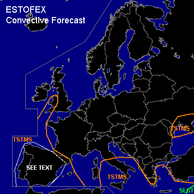
There is a slight risk of severe thunderstorms forecast across the eastern Mediterranean and Cyprus
SYNOPSIS
Warm air is advected east of a cold front with a developing wave over the Atlantic. Previous days have seen convection developing in this warm airmass over the Iberian Peninsula. Special feature of interest is the weakening tropical storm Vince, which has made landfall this morning over southern Portugal/southwestern Spain. Other low pressure systems of significance are found over the eastern Mediterranean Sea and the northern Black Sea with enhanced dynamic vertical motions and associated convective development.
DISCUSSION
...eastern Mediterranean and Cyprus...
A slight risk is issued for the well-organised mesoscale convective system that is visible on satellite imagery. The configuration suggests fairly strong deep layer shear, as also indicated by model fields (>15 m/s 0-6 km). 0-3 km SR helicity will be somewhat enhanced as well. Some cells,especially near the southern end, may develop rotation. Large hail and severe gusts appear the main threats, and a few waterspouts are possible as well.
...Iberian Peninsula...
GFS 18Z/00Z shows a really marginal setup for CAPE, while NMM 12Z seems more positive about the amount of instability. Expect some storms to form in a convergent flow pattern and near orographic features. Deep layer shear will be rather weak at around 10 m/s, while 0-3 km SREH and 0-1 km bulk shear do somewhat allow for low-level mesocyclogenesis. Storms will likely be not to be very organised in structure and the threat of severe weather low.
The weakening tropical storm Vince that made landfall in southern Portugal/Spain bears almost no convective activity with it, but as 00Z Gibraltar shows, shear and helicity profiles can be much more impressive ahead of this system than models have picked up - for example, GFS has only 15 m/s deep layer shear while this sounding shows 25 m/s. Any storm that is able to form near this cyclone, especially the northeast quadrant, can profit of the shear environment and become a supercell with the main risk of severe winds and a tornado.
The area of risk and expected number of storms preclude a risk category, but the chance of storms is highest for the south coast of Spain.
#