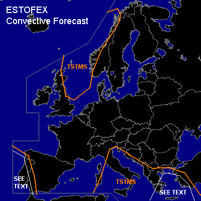

CONVECTIVE FORECAST
VALID Sun 09 Oct 07:00 - Mon 10 Oct 06:00 2005 (UTC)
ISSUED: 09 Oct 07:14 (UTC)
FORECASTER: GATZEN
SYNOPSIS
Strong high over northeastern Europe remains ... while upper cut-off low over northern Mediterranean propagates eastward. To the west ... well-developed ridge is expected to develop reaching from western Africa to France and further to northeastern Europe. A deep southwesterly flow will form at he eastern flank of this ridge ... affecting northwestern and northern Europe. Embedded strong vort-max propagates northeastward over Scandinavia today. At lower levels ... a cold front moves eastward at the northern flank of European ridge ... and cold maritime airmass spreads into North Sea region and Scandinavia duing the period. From northern British Isles to northwesterm Scandinavia ... this airmass is forecast to be convectively mixed in the range of the upper short-wave trough ... and instability is forecast. Showers and a few thunderstorms should develop. Weak vertical wind shear is forecast and chance for organized convection will be low. Over southern Europe ... warm and unstable airmass is expected over south-central and southeastern Mediterranean in the range of propagating cut-off low. CAA is forecast during the day west of Aegean Sea. Over southwestern Europe ... warm maritime airmass advects into western Iberian Peninsula.
DISCUSSION
...Western Iberian Peninsula
...
Warm maritime airmass spreads northward over western Iberian Peninsula. Rich low-level moisture and rather steep lapse rates should be present ... and CAPE is forecast by latest GFS model run. On Sunday ... weak developed upper vort-maxima are forecast to travel northward at the eastern flank of a cut-off low ... and QG forcing is expected over western Iberian Peninsula. Showers and thunderstorms present over the Atlantic should spread northeastward affecting western Iberian Peninsula during the period. Southeasterly low-level winds ... and relatively strong upper SW-erly jet create strong DLS .... reaching 25+ m/s over Iberian Peninsua late in the period. Thunderstorms that form may be severe ... capable of producing large hail, severe wind gusts and intense precip. However ... low-level moisture is questionable over Iberian Peninsula ... as SE-erly winds are expected ... limiting the chance for severe thunderstorms.
...Southeastern Mediterranean
...
At the southern/southeastern flank of the upper cut-off ... DLS will reach more than 20 m/s during the period. Upper vort-maxima are expected to travel northeastward. Affected airmass is characterized by relatively steep low-level lapse rates ... and GFS model output shows CAPE up to several 100 J/kg. On Sunday ... CAA is expected as northerly surface winds are forecast in the wake of surface low-pressure systems over southeastern Aegean ... and amount of CAPE is forecast to weaken. Nevertheless ... convective activity should go on during the period spreading northeastward into Aegean Sea. Although DLS and CAPE are expected to weaken during the day ... a few isolated severe events are not ruled out. Best chance should exist over Aegean Sea region ... where upper vort-max/ low-level convergence is expected during the day ... and severe wind gusts, isolated large hail, intense precip and tornadoes may be possible. An upgrade to SLGT may be warrant.
#