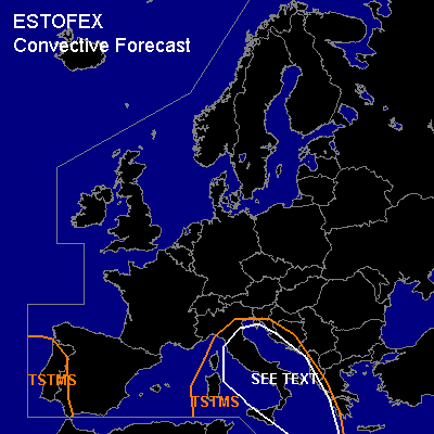

CONVECTIVE FORECAST
VALID Sat 08 Oct 06:00 - Sun 09 Oct 06:00 2005 (UTC)
ISSUED: 08 Oct 06:36 (UTC)
FORECASTER: DAHL
SYNOPSIS
Central Mediterranean upper low is slowly weakening ... and expected to move towards the Ionian Sea during the period. Another upper low ... also in the process of weakening ... is approaching the Iberian west coast ... supporting advection of moist subtropical/Atlantic air mass across SW Iberia late in the period. Vigorous upper frontal zone is present over NRN Europe ... with imbedded ... intense trough crossing the British Isles and the North Sea on Saturday ... lifting into Scandinavia until Sunday morning. Large SFC high is covering W Russia and the eastern half of Europe ... with quiescent conditions prevailing over SRN portions of Europe.
DISCUSSION
...central Mediterranean...
Low-level thermodynamic profiles across warm/moist air E of the upper low feature nearly saturated boundary layer ... low LCL heights and little/no CINH ... with CAPEs up to 500 to 1000 J/kg. Shear in the lowest layers seems to vary spatially ... but should be maximized across the Balkan Adriatic coast ... though probably not exceeding 10 m/s. Deep shear should decrease to about 10 m/s over the next few hours ... altogether suggesting that severe TSTM threat will weaken during the day though a few brief/weak tornadoes may occur given favorable boundary-layer fields. Also ... especially in the first few hours of the period over the Ionian Sea ... marginally severe wind/hail events may occur. Threat seems to be too low for a SLGT however.
...SW Iberian Peninsula...
GFS and NMM both advertise weak CAPE spreading across SW Iberia late in the period. Thinking is that this activity will be associated with LL WAA ... likely remain elevated ... with bulk of TSTMS staying off shore. Shear should be too weak to support organized-severe TSTM threat.
...Norwegian Sea ... northen North Sea...
Cellular convection has formed in the polar air associated with the N-Atlantic upper trough. This convection has failed to produce widespread lightning thus far ... and will likely not become better organized due to lack of mesoscale/linear upward forcing. Expect gusty winds with this activity and possibly some small hail ... but below severe levels.
#