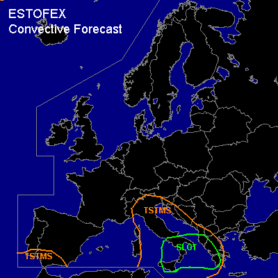
CONVECTIVE FORECAST - UPDATE
VALID Fri 07 Oct 16:00 - Sat 08 Oct 06:00 2005 (UTC)
ISSUED: 07 Oct 15:54 (UTC)
FORECASTER: TUSCHY
There is a slight risk of severe thunderstorms forecast across Ionian Sea and surrounding areas
SYNOPSIS
Please refer to the outlook, released at 06 Oct 18:03 (UTC)!
DISCUSSION
...Ionian Sea and surrounding areas...
Convective activity more widespread than models indicated and ATM it looks like that NMM masters the situation the best... Latest satellite loops show strong line of storms, crossing Sicilia and moving eastward... Yesterday, NMM showed enhanced low level shear over parts of Calabria,Italy and latest synop datas along the coastal areas of Calabria show strong offshore flow with up to 15kt... This backing wind field could locally enhance the shear...storms will arrive during the next few hours in south Italy and a few storms could pose a risk for severe wind gusts and isolated large hail....one or two tornadoes can't be ruled out.
Went with a pretty far eastward extension of the risk area, because low level shear should increase during the night hours over most parts of the Ionian Sea...on the other hand , models agree that storms will leave best instability axis [ situated over the central Ioanian Sea ]so all-over threat should slowly diminish...However, enhanced low-level shear could pose the risk for a few organized storms with a severe wind gust and low-end tornado threat...Current thinking is that threat will be high enough for warranting a marginal SLGT risk.
#