CONVECTIVE FORECAST
VALID Fri 07 Oct 06:00 - Sat 08 Oct 06:00 2005 (UTC)
ISSUED: 06 Oct 18:03 (UTC)
FORECASTER: TUSCHY
SYNOPSIS
High-over low flow pattern will persist during the forecast period, although the upper-level low/cut-off system over the central Mediterranean area will start a slow weakening trend...An impressive upper-level trough will enter the forecast area from northwest and its WAA should support the strong high pressure area over central and eastern Europe.
DISCUSSION
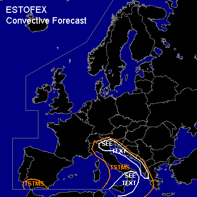
...Sicilia,Tyrrhenian and Adriatic Sea, Italy, the coastal areas of western Greece,Albania,Serbia and Montenegro,Bosnia and Herzegovina,Croatia and Slovenia...
Slightly weakening upper-level low will be the main focus for convective activity over the central Mediterranean area...Although the whole TSTM risk area could see a few severe TSTMS ( main risk should be a severe wind gust threat), model pool converges towards two hot spots.
The first one will be an area around Sicilia towards the early evening hours...It should be mentioned that models strongly disagree ( NMM and BOLAM show intense convective signals, while GFS develops a broader and weaker area of activity mainly to the north), but looks like eastward moving trough axis and smaller disturbances (induced by the higher terrain over N-Algeria/Tunesia)will provide enough lift for convective activity...GFS and NMM show a splitting jet over this area with a few pieces crossing the area...this will also be the focus for localized UVV maxima...All-over cool-down of mid-levels should cause instability values of 500-1000 J/kg SBCAPE...
Although models continued to weaken shear during the last runs, about 20m/s DLS should be available...enough for a few severe wind gusts...It depends of the possible developing low-level depression and its strength [ NMM very
aggressive with up to 12m/s 0-1km shear over Calabria(Italy)]and an upgrade would be necessary because of a increasing tornado threat.
The second area would be further eastward...models show line of storms, crossing the Adriatic Sea during the night hours... Slightly enhanced 0-1km RH values along the coastal areas should cause one or two tornadoes and a few severe wind gust reports...Extended the SEE TEXT area over parts of NE Italy, because advection of a more humid airmass from the Adriatic Sea should help to disequilibrate atmosphere enough for TSTM development further inland.
#