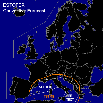

CONVECTIVE FORECAST
VALID Wed 05 Oct 08:00 - Thu 06 Oct 06:00 2005 (UTC)
ISSUED: 05 Oct 08:36 (UTC)
FORECASTER: GATZEN
SYNOPSIS
High over low flow pattern present over Europe ... with a well-developed upper trough/cut-off present over northern Mediterranean and strong high centered over southern Baltic Sea. A strong upper jet surrounds the upper trough affecting most of the Mediterranean as well as Alpine region, southern/central France, northern/eastern Spain. Another strong upper jet curves around the upper high over northern Europe from northern North Sea/Iceland to northern Scandinavia ... eastern Finland ... northern Russia. At lower levels ... stable airmass dominates European high and spreads into western and central Mediterranean in the weak of the upper cut-off. East of a cold front crossing Italy ... warm airmass originating from northern Africa spreads northward.
DISCUSSION
...Southern central Mediterranean, southern Italy, Adriatic
...
A strong mid/upper level jet streak reaching 50/80 kts @ 500/300 hPa level travels ENE-ward at southeastern flank of the cut-off low ... reaching central Italy on late Wednesday. Associated upper vort-max propagates NE-ward over Italy into Adriatic, and southern Balkan region. At lower levels ... relatively moist convectively mixed airmass is present over central Mediterranean as indicated by latest Brindisi sounding ... and isolated showers/thunderstorms have formed over Adriatic/northern Mediterranean. On Wednesday ... warm airmass originating from northern Africa is expected to spread northward east of a cold front over central Mediterranean. This airmass is characterized by strong capping inversion at midlevels. Aloft ... models indicate CAPE up to 1000 J/kg as surface dewpoints are forecast to reach 20+ C. Given actually quite weak low-level moisture ... amount of model CIN/CAPE seems to be not realistic ... and we expect lower CAPE and quite strong capping inversion over most of south-central Mediterranean today. As the upper vort-max approaches ... and cold front enters the region ... showers and thunderstorms are forecast due to QG forcing /WAA and DCVA ... that should be mostly elevated. Given relatively strong DLS ... a few well-developed thunderstorms may form ... and isolated large hail/severe wind gusts are not ruled out. Thunderstorms that root to the boundary layer will have a potential to produce tornadoes given easterly surface winds. Best chances for surface-based convection seem to exist along the frontal boundary, where low-level moisture should be maximized. Allover threat will be low, and a categorical risk seems to be not warrant. Over Adriatic region/Balkans ... intense precipitation is expected as elevated MCS may form at the leading edge of the WAA regime.
...Northwestern Mediterranean
...
Underneath the center of the cut-off low ... rather steep low-level lapse rates ... rich boundary-layer moisture and resulting low-level CAPE/weak CIN ... as well as weak vertical wind shear are present ... and a couple of waterspouts are forecast.
#