CONVECTIVE FORECAST
VALID Sat 01 Oct 06:00 - Sun 02 Oct 06:00 2005 (UTC)
ISSUED: 30 Oct 17:39 (UTC)
FORECASTER: TUSCHY
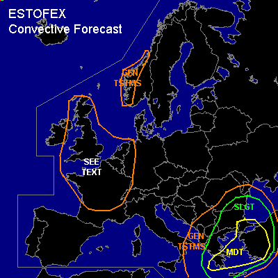
There is a moderate risk of severe thunderstorms forecast across southeastern Greece,western Turkey and most parts of the Aegean Sea
SYNOPSIS
Low-index weather pattern continues over Europe....Major trough over NW Europe keeps up to amplify furthermore as a consequence of a strong upper - level jet streak entering the system from the west....Downstream of this trough, strong WAA helps to weaken another trough over central-southeastern Europe and where models forecast the development of a pretty strong cut-off system....This depression will cross the Aegean Sea during the forecast period and should contribute for a pretty active severe weather day in this region !
The western Mediterranean area will benefit from the aforementioned WAA of the NW Europe trough and strong capping will suppress convective activity...NE Europe will also see dry conditions under the influence of a strong Russian high pressure area.
DISCUSSION
...southeastern Greece,western Turkey and most parts of the Aegean Sea...
A cool and stable airmass from central Europe overspreads the Adriatic Sea from North to South...System of interest will be strongly sloped ( upper-level cut-off over the Adriatic Sea and low-level depression somewhere over Greece), which is a sign for a very active system...Cut-off will shift eastward over Greece and will reach western Turkey during the latter part of the forecast period.
Main concern looks like to be eastward moving cold front, exiting the Ionian Sea during the Noon hours....Model forecast 500-1000 J/kg of instability in front of the cold front, which will be enough for a developing squalline, crossing Greece from west to east during the afternoon hours ( model pool slightly disagree in exact timing ). 500hPa wind forecasted to be up to 35m/s and DLS values will be in the range of 25-30m/s... Forecast soundings ( Athen 12Z )also show steep low-level
lapse rates over the region so that impulse can easily be mixed down....Current thinking is that severe squalline will cross Greece with a widespread damaging wind threat...one or two tornadoes can't be ruled out.
Severe squalline will cross the Agean Sea and reach western Turkey, where cold front is forecasted to slow down ( as a consequence of a more parallel alignment in respect to the background flow )....0-1km SRH values will increase significantly during the night hours ( up to 15m/s ) and this combined with high DLS values will pose a risk for widespread severe TSTM development...Included most part of western Turkey in the MDT area, because of an enhanced tornado threat...even a strong tornado possible in this area....Forecast sounding from Afyon shows a veering profiler with low LCL values....Again, a widespread severe wind gust threat and isolated large hail risk will be present...There also will be an attendant flash flood risk when front slows down ( storm clustering and training storm development)
Northern part of squalline will reach the southwestern Black Sea area during the night hours, but will come under an increasingly diffluent upper-level flow pattern...as a result, models strongly disagree of the final position of the front during the early morning hours....went with a medium of the model pool.... Again,there will be a widespread severe wind gust risk.
Next area of interest will be the region north of the low-level depression ( situated over Greece)... Models like GFS/NMM forecast broad backing wind field over Bulgaria with enhanced low-level shear ( up to 10m/s+ )...GFS instability forecast looks reasonable with up to 300J/kg ( Sofia had ~ 100J/kg yesterday 12Z )and current thinking is that scattered storms will develop over Bulgaria...DLS values pretty low, but expect that there will be a risk for a few tornadoes and an isolated severe wind gust threat.
Finally there will be quite a conducive waterspout-pattern for the northwestern/northern Aegean Sea, when cold core of upper-level cut-off enters the 22-24°C warm water surface.
...France, northwestern Germany,Netherlands,Belgium, United Kingdom and eastern Ireland...
Impressive upper-level trough will amplify during the forecast period....Cold mid-level airmass should disequilibrate atmosphere enough for scattered TSTM development...Weak kinematic parameters forecasted under the base of the trough, so there will be only a marginal severe wind gust/hail risk.
#