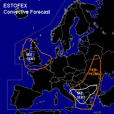
CONVECTIVE FORECAST
VALID Fri 30 Sep 06:00 - Sat 01 Sep 06:00 2005 (UTC)
ISSUED: 29 Sep 16:20 (UTC)
FORECASTER: TUSCHY
SYNOPSIS
Impressive upper - level trough, seated southwest of Iceland [ 15 UTC ], will shift eastward during the next 24 hours, crossing parts of northwestern Europe...Downstream of this system, strong WAA will help to strengthen a ridge furthermore over most parts of western Europe....another trough over central Europe continues to amplify and induces weak cyclogenesis at the surface over parts of Greece.
DISCUSSION
...most parts of Ireland and United Kingdom...
Models agree in eastward movement of active cold front over Ireland and United Kingdom during the forecast period...Strong WAA helps to warm-up the atmosphere in the low-/mid levels in front of the cold front...GFS also forecasts a short wave, crossing United Kingdom from southwest during the noon hours...This would inhibit any significant insolation (WAA and strong UVV values of short wave will help to produce widespread prefrontal cloud coverage)...Cold front should cross most parts of United Kingdom during the late afternoon and evening hours....Low-end instability values forecasted by models, but ATM, I only see a prefrontal environment ,which won't be conducive for significant convection development....Area monitored for signs of mid-level drying ( strength/placement of dry slot )...
Current thinking is that isolated storms will develop along eastward moving cold front, with an attendant threat of severe wind gusts, given strength of wind field. Enhanced 0-1km SRH values and low LCLs would also pose a risk for an isolated tornado.
During the night hours, base of eastward moving trough with very cool mid levels could destabilisize atmosphere enough for isolated TSTM development, but weakening kinematic parameters will preclude significant storm organisation...main threat will be a marginal hail risk.
...parts of southeastern Europe...
Southeastward moving cold front will arrive in western Romania - Serbia and Montenegro during the afternoon hours....strengthening baroclinic zone and broad area of upper-level divergence will help to introduce weak cyclogenesis over Greece.... only weak instability forecasted over land, but expect scattered storm development...although developing surface depression will help to strengthen shear values, current thinking is that threat will be too marginal for upgrading...Main threat will be an isolated severe wind gust and marginal hail risk.
#