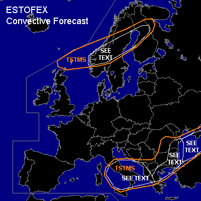

CONVECTIVE FORECAST
VALID Tue 20 Sep 06:00 - Wed 21 Sep 06:00 2005 (UTC)
ISSUED: 20 Sep 07:55 (UTC)
FORECASTER: VAN DER VELDE
SYNOPSIS
An cold upper low near the western Balkan and associated low sea level pressure area cause steep lapse rates and convergence to support thunderstorms. A comma cloud is traversing over Norway into Finland.
DISCUSSION
...Scandinavia area...
Comma cloud convection forecast to pass Norway in the afternoon and Finland at night. Though convection will be quite shallow (5 km), with strong DL shear over 30 m/s and strong LL shear over 12 m/s and SREH locally over 200 m2/s2, short-lived mesocyclones could develop that may spawn a tornado or two. Additionally, marginally large hail and strong gusts could occur.
...Italy area...
00Z soundings of Brindisi and Pratica di Mare have shown steep lower and middle lapse rates with MLCAPE over 600 J/kg and humid boundary layers. Wind profiles show 0-3 km winds rather weak with a more abrupt increase above, so that moderate bulk DL shear vectors are basically not effective over the lowest 3 km with regard to updraft rotation. The setting looks perfect for scattered waterspouts, however, which may form best at lines of convergence for their source of vorticity. Marginally large hail may occur on an isolated basis.
...Black Sea and coasts...
Spout-type tornadoes may well form over the Black Sea, though there is no cold airmass being advected over it that creates super-adiabatic low-level lapse rates. Vertical wind shear is much absent, aiding upright stretching of vorticity.
...Eastern Romania, eastern Bulgaria and eastern Greece...
Warm and humid air is advected inland by the eastern flow around the low. As zone of consistent midlevel differential vorticity advection moves into the region, expect storms to cluster in coastal areas and be sustained in that position for long enough to cause local flash floods. Additionally, marginally large hail and waterspouts are not to be excluded. 00Z sounding in Romania shows only elevated instability, so strong SREH and LL shear conditions there will likely not be effective in producing tornadoes.
#