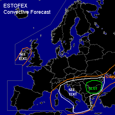
CONVECTIVE FORECAST
VALID Mon 19 Sep 06:00 - Tue 20 Sep 06:00 2005 (UTC)
ISSUED: 18 Sep 18:13 (UTC)
FORECASTER: TUSCHY
There is a slight risk of severe thunderstorms forecast across most parts of Bulgaria, southern Romania and eastern Serbia and Montenegro
SYNOPSIS
Intense depression west-southwest of Norway, will race northeastward during the next 24 hours and accompanying WAA will help to strengthen the ridge over central Europe furthermore....This process will help to weaken the broad upper - level trough ( positioned from southern France towards Ukraine )and only slow eastward movement of this system expected.
At the surface, airmass boundary over eastern Europe expected to shift slowly southward and be placed somewhere over Hungary and central Romania ( a blend of the model pool ).
DISCUSSION
...most parts of Bulgaria, southern Romania and eastern Serbia and Montenegro...
Early in the forecast period, short wave trough should cross most parts of the Adriatic and Ionian Sea, where models forecast SBCAPE values of about 1.5 KJ/kg.... Although arriving vort max and unstable airmass will be present, not quite sure ATM how far south TSTMs will develop...Once again, very dry airmass from northern Africa will reach the Ionian Sea and models also forecast pretty high CIN values...However, I expanded the SEE TEXT area that far south, because mid-level cooling could be high enough for an isolated storm development...DLS values of 25-30m/s would be more than adequate for storms to acquire severe storm status pretty fast....main risk will be severe wind gusts, but current thinking is that threat will be too low for warranting a categorical risk for parts of Greece and the Ionian Sea....
Further northward, conditions favorable for widespread TSTM development...weak kinematic parameters should preclude widespread storm organisation, but an isolated severe wind gust and waterspout/tornado report will be possible, especially along coastlines, where mesoscale processes should locally enhance LL shear.
Later in the period, slowly southward moving airmass boundary will be the main focus for TSTM development....Enhanced 0-1km SRH values and low LCLs will pose a risk for one or two tornadoes and an isolated severe wind gust threat.
During the afternoon hours, strong upper-level streak will enter Greece and models try to develop a weak low-pressure area in its left exit region...Went with GFS ( pretty consistent in this scenario ), which shows a broad backing wind field, developing over Bulgaria and southern Romania with 0-1km SRH values up to 300m**2/s**2....Models forecast up to 700 J/kg MLCAPE and strong forcing, so
widespread TSTM development expected in the SLGT risk area... There will be an enhanced tornado chance especially along southward moving airmass boundary...otherwise an isolated severe wind gust will also be present.
Important to note that strong upper-level divergence,weak DLS values and slow movement of airmass boundary will pose a risk for heavy rainfall and flash flooding in this area, especially when storms start to cluster.
...Ireland...
Eastward moving cold front of rapidly intensifying depression west of Norway will reach the area of interest early in the morning hours....strong THETA-E tongue with low-end instability values present and isolated TSTM development possible...About 20m/s DLS will be enough for a severe wind gust risk, but threat too marginal for upgrading.
#