CONVECTIVE FORECAST
VALID Sat 17 Sep 06:00 - Sun 18 Sep 06:00 2005 (UTC)
ISSUED: 16 Sep 18:05 (UTC)
FORECASTER: TUSCHY
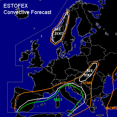
There is a slight risk of severe thunderstorms forecast across most parts of the western and central Mediterranean area,eastern Spain, most parts of Italy and Sicilia
SYNOPSIS
Impressive low-index pattern underway for most parts of Europe...highly amplified upper - level trough will be placed over most parts of western, central and northern Europe and will even reach parts of northern Africa... Downstream of this system, broad area of strengthening WAA should reduce convective activity....Over northern Norway, strong depression will reach Europe and should quickly shift eastward..
At the surface, arimass boundary - over parts of Hungary and western Ukraine - will slowly shift east/southeastward as a consequence of a strengthening high pressure area
over portions of central Europe ( and strong CAA under the
base of the trough ).
DISCUSSION
...most parts of the western and central Mediterranean area,eastern Spain, most parts of Italy and Sicilia...
Went with a broad SLGT area, because of model discrepancies concerning the exact position of numerous smaller jet streaks....latest WV pictures showed a weakening upper - level low pressure over SW Spain which will enter the western Mediterranean area during the morning hours...interesting to note, that models agree in opening up the system and shifting an open wave northeastward over the SLG risk area....At the same time, models agree in widepread pressure drop over the risk area and they try to develop a weak low pressure area somewhere over northern Italy.
Current thinking is that first round of convection will develop during the early morning hours over the west-central Mediterranean area under the base of the northeastward propagating short wave...A decrease of mid - level temperatures ( 2-5°C ) will help to further intensify the lapse rates over a broad area and forecasted ~ 1 KJ/kg CAPE by models looks reasonable.... as a consequence, cluster of storms should develop and move northeastward, reaching northern and central Italy during the later afternoon/early evening hours.... Although bulk of convective precipitation signals displaced by best kinematic parameters, uncertainnes of the development of the low - level depression and forecasted ~15m/s DLS will be enough for issuing a categorical SLGT... severe wind gust threat will be the main risk, especially if a line of storms can develop...a very humid airmass in place should help to produce heavy precipitation in strongest storms.
Second round of convective development is shown consistently by models somwhere NE of Tunesia... If storms can develop, DLS values up to 25m/s would be more than
adequate for storm organisation with severe wind gust being the main risk.
Developing low-level pressure area over northern Italy should help to produce strong offshore flow over southern France, which would advect a drier and more stable airmass
over parts of the western and north-central Mediterranean area....ATM not clear how far south this windshift zone will move, so considerable uncertainness exist in third convection development....current thinking is that new round of storms will develop over SE Spain and will move northeastward towards the central Mediterranean area...NMM shows slightly enhanced 0-1km SRH values over SE Spain which will help for some storm organisation and a slightly enhanced tornado risk.... Otherwise an isolated severe wind gust report can't be ruled out.
...Hungary, western Romania and Ukraine...
Focus for isolated TSTM development will be the slowly southeastward moving airmass boundary....Yesterday SFLOC reports showed little activity along the front, but airmass
will be a little bit more unstable in the SEE TEXT area
( ~ 200 J/kg )...isolated to scattered storm development expected along the front...models show a belt of strengthening low-level shear along the front, combined with low LCLs... This should locally enhance the tornado risk, although storm coverage too low for upgrading....otherwise a few severe wind gusts can be expected.
...Norway and parts of Sweden...
Strong depression will arrive in the SEE TEXT area during
the late afternoon hours over northern Norway...Accompanying WAA of this system will help to strengthen the cap over the area of interest, but strong forcing forecasted to reach Norway and western Sweden during the afternoon hours , which should enhance the risk for an isolated elevated TSTM.... DLS would be more than adequate for some storm organisation and main risk would be isolated large hail...Strongly veering profilers and very high SRH values present, but don't think that storms will root in the surface boundary layer as a consequence of a strengthening cap.
#