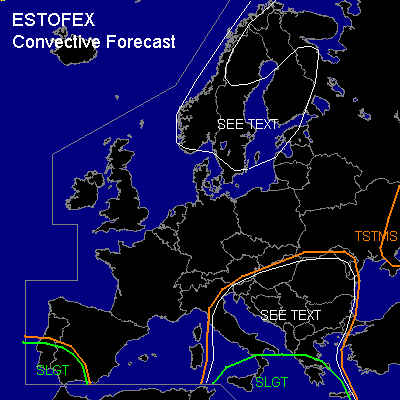

CONVECTIVE FORECAST
VALID Wed 14 Sep 06:00 - Thu 15 Sep 06:00 2005 (UTC)
ISSUED: 13 Sep 17:25 (UTC)
FORECASTER: GATZEN
There is a slight risk of severe thunderstorms forecast across east-central Mediterranean, southern Italy, southern Greece
There is a slight risk of severe thunderstorms forecast across southwestern Iberian Peninsula
SYNOPSIS
High over northern Atlantic ridges into central Europe ... and relatively zonal flow is present from British Isles to southern Scandinavia and northern Russia. Over the Balkans ... upper cut-off low intensifies while moving southeastward. At lower levels ... mostly stable maritime airmass advects eastward over northern and central Europe, while unstable airmass is expected in the range of a low over Balkans and central/eastern Mediterranean.
DISCUSSION
...Central and eastern Mediterranean, Balkans
...
A sharp upper trough is present over northern Mediterranean ... with an axis reaching from northern Balkans to southern Iberian Peninsula. Southern part of this trough cuts off southwest of Iberian Peninsula ... and DAVA is expected over western Mediterranean. To the east ... remaining cyclonic vorticity is expected to propagate southeastward ... crossing southern and central Italy and western Greece on Wednesday ... as another cut-off forms southwest of Greece. At lower levels ... warm and quite unstable airmass present over northern Balkans is expected to spread southward into southern Balkans in the range of the upper trough. Over central/eastern Mediterranean ... rather dry low-level airmass is present ... that is forecast to destabilize in the range of the upper trough axis due to height falls and increasing low-level moisture. On Wednesday ... latest GFS model run shows CAPE around 500 J/kg over central and southern Balkans and up to 1000+ J/kg over central Mediterranean. Although amount of instability remains uncertain over the water surface ... significant CAPE is expected to build in the range of the upper trough ... and showers and thunderstorms should develop. In the range of the upper vort-max/trough axis ... vertical wind shear will be quite low ... and organized thunderstorms should be unlikely from central Balkans to central Italy. To the south ... strong upper jet streak will be present at the southern flank of the upper trough ... and deep layer vertical wind shear is expected to reach 25+ m/s. Although models indicate that widespread convective activity should develop north of this region with strong DLS ... isolated thunderstorms may form over southern Italy region due to insolation ... spreading southeastward into Mediterranean Sea. Multicells and mesocyclones are forecast ... capable of producing large hail and severe wind gusts. Due to rather dry low-level airmass and relatively weak low-level wind shear ... chance for tornadoes seems to be quite low. Increasing QG forcing in the range of intensifying upper low may lead to MCS formation over southern Italy/ southern Adriatic Sea ... spreading eastwards into western Greece during late Wednesday/early Thursday. Severe wind gusts and intense precip should be the main severe threat ... while isolated large hail and one or two tornadoes are not completely ruled out.
...Southwestern Iberian Peninsula
...
Unstable airmass is present in the range of the trough axis over southern Iberian Peninsula region ... characterized by rich low-level moisture, weak CIN, and well-mixed layers aloft as indicated by latest Gibraltar sounding. On Wednesday ... instability is expected to increase as upper trough cuts off and intensifies SW of Iberian Peninsula. Showers and thunderstorms should develop in the range of the upper cut-off as low-level convergenze is expected north of a surface low-pressure system developing over Morocco. Thunderstroms that form should be well-organized given favorable vertical wind shear ... with low-level easterly winds and SWerly winds aloft ... and supercells are forecast ... capable of producing large hail and severe wind gusts. One or two tornadoes are not ruled out as LLS should be relatively strong. Convective acitivity should go on during the night hours as low-level convergence will remain.
...Scandinavia...
Strong upper vort-max moves eastward over Scandinavia during the period. Although instability will be limited in convectively mixed maritime airmass ... showers that form may produce lightning. Strong LLS will be present in the range of the trough axis ... and severe wind gusts are forecast. Large hail and tornadoes are not completely ruled out. Allover threat seems to be low.
#