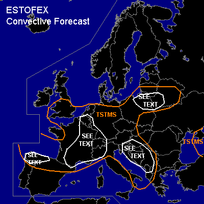
CONVECTIVE FORECAST
VALID Sat 10 Sep 06:00 - Sun 11 Sep 06:00 2005 (UTC)
ISSUED: 09 Sep 17:56 (UTC)
FORECASTER: TUSCHY
SYNOPSIS
Decoupled from the polarfront jet band over extreme northern Europe, two systems will affect the weather over most parts of Europe...First one is an impressive upper-level low pressure next to the western French coast, which should slowly shift southeastward during the next 24 hours, caused by strong WAA, downstream of extratropical storm "Maria" and a strong upper-level streak, orbiting this low pressure system...This depression should stay positively tilted during the forecast period, so don't expect strong WAA downstream of this system...this helps our second upper-level low over the Black Sea area to remain nearly stationary....Otherwise, weak pressure contrasts will be present over most parts of southern, eastern and central Europe...Embedded in the strong westerlies, an active shortwave trough races eastward over parts of northeastern Europe and will also be the focus for some storm development.
DISCUSSION
...France,Monaco,northwest Italy,Switzerland, Austria, Belgium, the Netherlands,parts of southern Great Britain,Slovenia, Croatia,Bosnia and Herzegovina,Serbia and Montenegro,western Romania,Hungary,Slovakia and Czech Republik ...
During the early part of the forecast period, storms will continue to develop along an eastward moving cold front,especially over southeastern France, under the influence of a coupled upper-level jet structure...about 15m/s DLS will be enough for some isolated storm organisation...Instability values of mainly about 100 to isolated 300 J/kg would be enough for isolated to scattered TSTM development...main risk will be a segregated severe wind gust and marginal hail.
Later in the forecast period, models show a strengthening instability tongue downstream of eastward propagating cold front and this looks quite reasonable, given models insolation forecast and strengthening southerly flow ahead of the front...new round of storms will develop along the southern end of cold front ( SE France ), when left exit region of upper-level jet enters the northern Mediterranean area...Current thinking is that a complex of storms will develop in a weakly shared environment during the late afternoon hours, moving northeastward towards Switzerland, southern and western Germany...good thermodynamic profilers, diffluent upper-level wind pattern and slow eastward movement of cold front will pose a risk for heavy rainfall with each storm and strong to isolated severe wind gusts...Parts of northwestern Italy should see strengthening low level shear during the night hours, which would enhance the severe weather risk, but uncertainness about strength of convective development precludes me for issuing a categorical SLGT risk ATM.
East of a line Netherlands-Switzerland, broad area of weakly capped and moderately unstable airmass will be present so expect scattered to widespread TSTM activity with main risk looks like to be a marginal hail risk and an isolated severe wind gust threat during the mature phase of each storm
The southeastern TSTM area will also experience such conditions with up to 15m/s DLS...this should be enough for an isolated severe wind gust threat.
...northwestern Spain...
10m/s low level shear and about 20m/s DLS present during the latter part of the forecast period, coupled with slight instability values... Right rear quadrant of strong upper-level jet should yield enough lift for an isolated TSTM...each storm would be in an environment, conducive for producing severe wind gusts and isolated tornados, but current thinking is that storm coverage will be too low for issuing a SLGT risk ATM.
...Kaliningrad,Lithunia and Latvia...
Focus for isolated to scattered TSTM development will be a warm front, which should transform into a slowly southward propagating cold front [ as a consequence of an eastward moving shortwave and a strengthening and also eastward moving high pressure area north of the frontal system ].
Again,only minor destabilisation and a weak shear environment prevent any widespread storm organisation, but modified low-level wind field along the boundary could locally enhance the risk for an isolated severe wind gust threat.
#