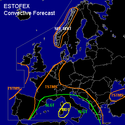

CONVECTIVE FORECAST
VALID Thu 08 Sep 06:00 - Fri 09 Sep 06:00 2005 (UTC)
ISSUED: 07 Sep 22:18 (UTC)
FORECASTER: GATZEN
There is a moderate risk of severe thunderstorms forecast across Sardinia region
There is a slight risk of severe thunderstorms forecast across western and central Mediterranean
SYNOPSIS
Eastern European high remains ... affecting eastern and central Europe. To the north ... rather zonal flow is present from western Europe to Scandinavia and further to western Russia. Several vort-maxima are embedded in the strong upper jet stream. Over Iberian Peninsula ... cut-off low diggs northeastward ... and rather strong upper jet affects western Mediterranean. At lower levels ... warm and unstable airmass dominates the Mediterranean. Warm airmass is also present over central Europe. Cold polar airmass spreads into northwestern and northern Europe during the period.
DISCUSSION
...Western and central Mediterranean, southern France, northeastern Spain
...
Moderate to strong instability indicated by latest ascends ... strong vertical wind shear expected by latest model output in the range of upper jet streak ... as well as QG forcing forecast at the cyclonic flank of the upper jet ... should lead to ongoing organized convective activity over most of western and central Mediterranean. Greatest chance for severe convection is forecast over Sardinia region ... where latest model output suggests CAPE up to 2000+ J/kg, DLS of more than 30 m/s, and strong QG forcing. Thunderstorms are expected to persist over a widespread area ... and should merge into mesoscale convective systems. Embedded supercells are also forecast given veering winds and rather strong SRH. Isolated large hail, severe wind gusts and tornadoes/waterspouts are forecast. Best chance for tornadoes is expected over west-central Mediterranean, where low-level vertical wind shear should be highest. Intense precipitation and flash flooding will pose a significant threat, especially over southern France and northeastern Spain. Convective activity is forecast to go on during the night hours.
...Western Scandinavia
...
Strong vort-maxima will travel eastward with the strong upper jet over northern Europe. Affected convectively mixed maritime airmass should be slightly unstable ... and thunderstorms may form along the western coast due to orographic lift and QG forcing. Thunderstroms that form may capable of producing severe wind gusts and a few tornadoes given strong vertical wind shear. Allover threat seems to be too low for a SLGT, though.
#