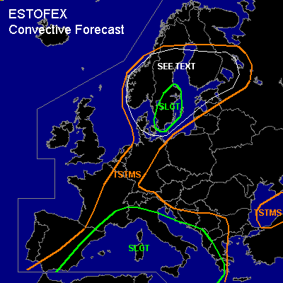

CONVECTIVE FORECAST
VALID Wed 07 Sep 09:00 - Thu 08 Sep 06:00 2005 (UTC)
ISSUED: 07 Sep 09:10 (UTC)
FORECASTER: GATZEN
There is a slight risk of severe thunderstorms forecast across western and central Mediterranean
There is a slight risk of severe thunderstorms forecast across southern Sweden
SYNOPSIS
High pressure system over eastern Europe remains ... and strong WSWerly jet affects northwestern and northern Europe at its northern flank. Over northern Iberian Peninsula ... a cut-off low diggs SEward ... yielding a southerly flow over western Mediterranean, and France. At lower levels ... an airmass characterized by high instability is present over parts of western and central Mediterranean ... where latest soundings indicate CAPE up to 3500 J/kg (Cagliari). Widespread convective activity goes on over western Mediterranean.
DISCUSSION
...Western and central Mediterranean...
Moist and unstable airmass is expected to remain over most of western Mediterranean region at the eastern flank of cut-off low over Iberian Peninsula. A relatively strong upper jet is present at the periphery of this cut-off ... and several embedded vort-maxima are affecting western and central Mediterranean. On Wednesday ... thunderstorms should go on ... especially underneath the cyclonic flank of the upper jet over northwestern Mediterranean. Given SE-erly surface winds and SW-erly upper jet ... vertical wind shear should be favorable for organized convection ... and latest ascends/ model output show DLS around 15-20 m/s and LLS of locally 10+ m/s. Multicells and embedded mesocyclones are forecast ... capable of producing intense precipitation, large hail, and severe wind gusts. Chance for torndoes is enhanced given low LCL heights and locally strong LLS ... and a couple of tornadoes/waterspouts are forecast. Later in the period ... a strong upper jet streak enters SWrn Mediterranean. As a consequence ... convective activity is forecast to intensify over western Mediterranean and eastern Iberian Peninsula. Thunderstorms should go on during the night ... and chance for severe thunderstorms will remain given strong DLS and increasing LLS during the night hours. Intense precip and flash flooding should pose a significant threat.
...Southern Scandinavia...
Strong upper jet streak visible on latest WV image travels eastward over northwestern Europe ... spreading into southern Scandinavia during the day. At lower levels ... a tongue of warm and unstable airmass now present over southern North Sea region is forecast to spread northward into southern Scandinavia ahead of a cold front. This airmass is characterized by steep low-level lapse rates and quite rich low-level moisture ... yielding CAPE up to 500 J/kg as indicated by latest Emden sounding. However ... unstable airmass over southern North Sea may not affect most of Denmark, Norway, and western Sweden ... where convectively mixed airmass originating from northern North Sea will be present in the wake of a surface cold front that is expected to move eastward ahead of the upper vort-max. Severe wind gusts and brief tornadoes are not ruled out, though. Best chances for organized convection seem to exist over SErn Sweden, where warm airmass may be present in the afternoon hours. Thunderstorms that form will likely organize given strong vertical wind shear ... with DLS up to 30 m/s and LLS up to 15 m/s ... and a few supercells may form ... capable of producing large hail and severe wind gusts. A few tornadoes are also expected given strong LLS, low LCL heights, and steep low-level lapse rates. One or two strong tornadoes are not ruled out. Thunderstorms may merge into bowing lines/MCS over the Baltic Sea later on ... and should reach southern Finland in the late evening/night hours. Although instability should be weaker than over Sweden ... a few severe events are not ruled out given strong vertical wind shear and QG forcing in the range of the upper vort-max. Severe wind gusts should be the main threat, but one or two tornadoes are not ruled out, ATTM. Allover threat seems to warrant a SLGT.
#