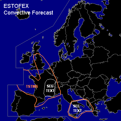
CONVECTIVE FORECAST
VALID Mon 05 Sep 06:00 - Tue 06 Sep 06:00 2005 (UTC)
ISSUED: 05 Sep 09:29 (UTC)
FORECASTER: GROENEMEIJER
SYNOPSIS
Monday at 06 UTC... at mid-levels a closed low pressure system can be found west of Britanny and south of a strong zonal jet near 65 N. Along with a broad ridge to its east the system is expected to shift eastward a few hundred kms during the forecast period. The western edge of a warm plume is marked by a cold front that extends from the Irish Sea to south-central England to the area around Bordeaux and then southwestward into Spain.
DISCUSSION
...France...
During the afternoon hours...surface-based storms, are expected to develop east of the front in response to solar heating especially over central, northern and eastern France and the southern Benelux.
It appears likely that storms will cluster rapidly. Storm clusters may be slow-moving as they are expected to back-build in an opposite direction to the low-level wind-vector, resulting in very low total storm motion and hence, high precipitation totals. Some threat of downbursts seem to be present as well as dry mid-levels are present ahead of the frontal zone, favouring storng evaporative cooling. However, low-level horizontal winds appear not to be strong anywhere limiting the threat somewhat.
Deep-layer (0-6 km bulk) shear is expected to be rather weak over central and southern France.
Large hail in the 2-4 cm range, may be possible with well-organized multicell storms.
But, as said, the main threat with Monday's storms appears to be intense rain and possible resulting flash flooding. The area most at risk stretches across eastern France, roughly from the Bourgogne southward along the Rhône Valley to the Mediterranean Sea. Numerical models suggest the development of stagnant backbuilding storm systems that may not cease until late Tuesday or even Wednesday morning.
...southern Italy, southern Adriatic, western Greece, Albania...
Near a weak upper-level low storms are ongoing. The comnbination of moderate (~15 m/s) shear and more than 1000 J/kg 500m-MLCAPE values have been observed, there appears to be a chance of rather strong storms occurring. Some threat of damaging winds and large hail will be present.
#