CONVECTIVE FORECAST
VALID Sun 04 Sep 13:00 - Mon 05 Sep 06:00 2005 (UTC)
ISSUED: 04 Sep 14:09 (UTC)
FORECASTER: VAN DER VELDE
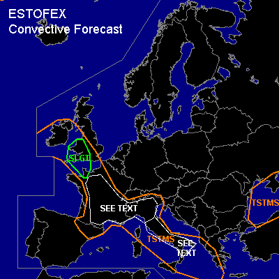
There is a slight risk of severe thunderstorms forecast across SWrn UK, NWrn France
SYNOPSIS
A tongue of warm humid airmass is advected over France into the western British Isles ahead of a low pressure area south of Ireland. Within the airmass a thermal trough causes convergence, but the regions of quasi-geostrophic lift are confined to weak troughs over Italy and over the Atlantic Ocean near the core of the upper low.
DISCUSSION
...SWrn UK, NWrn France...
12Z soundings do not show impressive instability, but sferics have been detected in the English Channel this afternoon. LL shear and DL shear are both enhanced and could certainly promote a good degree of convective organization and rotation in updrafts of storms. An isolated tornado or large hail event could result of this setup, as well as an isolated severe gust, given the strength of the midlevel winds and dry air.
...SEE TEXT over France and Nrn Italy...
12Z soundings and 06Z GFS model indicate instability of a few hundred J/kg MLCAPE in combination with a dry, weak shear environment. Currently a NW-SE convergence line moves eastward over France, and winds from the south creat also convergence at the south side of the Massif Central. The 12Z Lyon sounding seems most favourable for deep convection, the other soundings show a dry cap that may be overcome at a more isolated scale. The primary risk is that of severe downburst winds when midlevel dry air entrains into portions of storms with precipitation, enhancing downdraft negative buoyancy. Given the weak flow, storms tend to be immobile and flash floods may occur.
...SEE TEXT over central and Srn Italy...
12Z Brindisi and Pratica di Mare soundings show MLCAPE of around 1500 J/kg created by a moist layer (Td 20C) and steep low to midlevel temperature lapse rate. In the weak flow, storms tend to be immobile and flash floods may occur. Due to the large CAPE, large hail will be possible as well, and severe downbursts are not excluded as well, given cold pools that can be 14 degrees colder than the environment.
#