CONVECTIVE FORECAST
VALID Sat 03 Sep 06:00 - Sun 04 Sep 06:00 2005 (UTC)
ISSUED: 02 Sep 16:35 (UTC)
FORECASTER: TUSCHY
SYNOPSIS
Highly amplified weather pattern consistent during the forecast period with an active trough west of Ireland, moving slowly eastward...Downstream of this system, WAA will help to establish a pretty broad area with higher geopotential heights...Although this feature should suppress most of the storm activity over central and northern Europe, a short wave trough, which undercuts the high pressure area on the eastern flank, will be the focus for TSTM development in some parts of central Europe... This short wave rotates southward along the western edge of another broad upper-level trough over eastern Europe...An intense low pressure system over extreme northern Europe will move northeastward and will affect parts of northern Sweden and Norway.
DISCUSSION
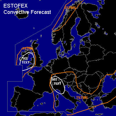
...parts of western Great Britain and Ireland...
Models disagree in developing convective precipitation signals over this area downstream of cold front...went with more aggressive GFS, which showed a pretty consistent trend in developing some signals over far western Great Britain and Ireland... Current thinking is that area will be under a thick cloud shield during most parts of the forecast period, so only low instability values should be materialized...Models agree in small disturbances moving towards the forecast period during the evening hours, which should provide enough lift for some isolated storms...Uncertainness in a few parameters [ insolation, instability ] is reason enough for only issuing low-end possibility values...NMM shows enhanced low-level shear, which could help for an isolated enhanced severe weather threat [isolated tornado, severe wind gust and a marginal hail risk] with each developing storm... A SLGT risk not necessary ATM, but area will be monitored for upgrade if parameters are more favorable than currently anticipated.
...parts of Switzerland and northern Italy...
Southward moving short wave trough will be accompanied by a strengthening wind field, which will affect especially the SEE TEXT area...DLS values up to 15m/s should be enough for some storms to organize...Went with a medium in convective precipitation forecast of model pool...isolated to scattered storms will also develop in the SEE TEXT area, where storms could pose a risk for an isolated severe wind gust... Threat too marginal for upgrading ATM.
#