CONVECTIVE FORECAST
VALID Wed 31 Aug 10:00 - Thu 01 Aug 06:00 2005 (UTC)
ISSUED: 31 Aug 10:30 (UTC)
FORECASTER: GATZEN
There is a slight risk of severe thunderstorms forecast across Great Britain and eastern Ireland
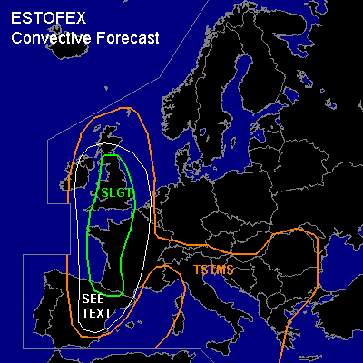
There is a slight risk of severe thunderstorms forecast across western France, northern Iberian Peninsula, western North Sea region
SYNOPSIS
Intense long-wave trough present over northeastern Altantic Ocean slowly propagates eastward. At its base ... well-developed short-wave trough/vort-max travels northeastward crossing most of western Europe during the forecast period. Associated strong jet streak travels from western Portugal to Scotland on Tuesday. To the east ... high pressure system over central Europe ridges into Scandinavia. Over central Mediterranean ... upper cut-off low propagates eastward.
DISCUSSION
...Great Britain and eastern Ireland
...
Focus of severe convective activity is expected over Great Britain. Plume of high THETA-E originating from Iberian Peninsula now located over Bay of Biscay region is forecast to spread northward into British Isles during the next hours. Latest soundings show rich low-level moisture and quite warm/stable airmass aloft ... and strong instability was not measured. Thunderstorms have developed from northern Bay of Biscay to western channel region, though ... indicating that CAPE is already present. During the day ... strong upper jet streak travels northward over western Great Britain/eastern Ireland ... and quite strong QG forcing is expected underneath the right entry region of this jet streak. At the surface ... models show deepening low pressure system moving from northern Bay of Biscay to southeastern Ireland. A surface cold front is expected from western France to western Great Britain on Tuesday, 15 UTC. Thunderstorms are forecast to develop along this cold front/convergence during the next hours and should spread NNEward over Great Britain. Strong deep layer wind shear is forecast in the range of the upper jet streak ... and thunderstorms should likely organize into multicells, bow echoes, and supercells ... capable of producing severe wind gusts, large hail, and intense precipitation. Increasing low-level vertical wind shear due to falling surface pressure over northern France/The Channel region and low-level bouyancy due to insolation ... seems to be also favorable for tornadoes. Amount of low-level instability is unclear ATTM ... given quite strong inversion indicated by latest soundings over western France. Especially over southern Great Britain ... low-level airmass is expected to be capped during the day ... and chance for organized thunderstorms is limited. However ... allover threat seems to be quite high today ... and an upgrade to MDT may be warrant. Later in the period ... persisting QG forcing/WAA advection is forecast ... and thunderstorms are expected to merge into a sqall-line/MCS moving northeastward into western North Sea. Severe wind gusts and flash flooding should be the most significant threat. Isolated large hail and tornadoes are not ruled out, though.
...Bay of Biscay, France, northern Iberian Peninsula, Benelux
...
East of a cold front that propagates eastward over France and Iberian Peninsula ... WAA is expected from northern Iberian Peninsula to western North Sea region during the period. Associated warm aimass is characterized by quite rich low level moisture ... and models show instability due to insolation during the day. Along the cold front ... thunderstorms are expected as upper vort-max/short-wave trough travels northeastward. Vertical wind shear is forecast to be in the range of 15-20 m/s ... and mesocyclones and multicells may form ... capable of producing large hail, severe wind gusts and intense precipitation. Allover threat seems to be quite low.
#