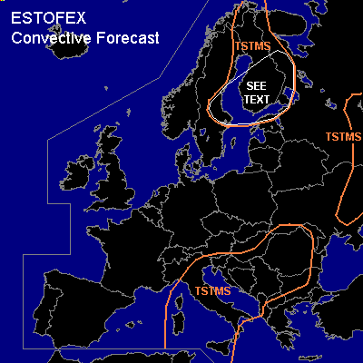

CONVECTIVE FORECAST
VALID Mon 29 Aug 06:00 - Tue 30 Aug 06:00 2005 (UTC)
ISSUED: 29 Aug 02:15 (UTC)
FORECASTER: GROENEMEIJER
SYNOPSIS
Monday at 06 UTC... main synoptic features include a weak low-pressure system over the southwestern Tyrrhenean Sea, a broad ridge with an axis over Germany and Sweden and a strong westsouthwesterly jet over the northern British Isles and the northern North Sea. The jet is located on the northern flank of a surface cold front and moves quickly eastward.
DISCUSSION
...central and eastern Scandinavia, northwestern Russia...
The aforementioned warm air-mass is slightly stable and is expected to move eastward over southern and central Scandinavia. Rather strong destabilisation is expected near the poorly defined cold front that marks the trailing edge of this air-mass. Rather strong DCVA-related vertical motion ahead of a vorticity maximum expected north of the British Isles at 18 UTC is likely important in this. Some CAPE is however forecast by GFS to form well ahead of this system across central Sweden late Monday afternoon. The vort max is expected over southern Norway around 00Z and along a line from western Finland to southern Sweden arond 06Z. As a result, profiles with rather steep low-level lapse rates are expected to (re)develop during the night over central Sweden and soon after over much of the Baltic Sea and Finland. Scattered to widespread convective storms are expected to form during the night as a result of this developing instability in combination with ample lift. Around 20-30 m/s 0-6 km bulk shear and around or slightly above 10 m/s 0-1 km bulk shear are expected. As a result convection will likely tend to organise into lines. Because of the strong shear, some of the storms may develop mesocyclones and a few tornadoes are possible. This would be especially the case if zones of strongly backing winds with height would form that favour high values of storm-relative helicity. If such more favourable areas for tornadogenesis are identified an upgrade to slight risk may be required.
#