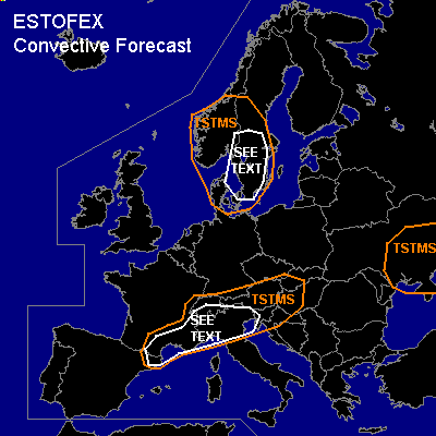
CONVECTIVE FORECAST
VALID Sat 27 Aug 06:00 - Sun 28 Aug 06:00 2005 (UTC)
ISSUED: 26 Aug 17:32 (UTC)
FORECASTER: TUSCHY
SYNOPSIS
Downstream of a strong upper-level jet streak, an amplifying trough will develop and shift southeastward over France during the forecast period, affecting northern Italy in the evening and night hours...Interesting to note that unseasonable strong trough over western Europe could even reach the southern Mediterranean area as a result of a strong jet, entering the trough from the northwest... Meanwhile, southern and eastern Europe will see warm and stable conditions while northern parts of Europe will be under the impact of a broad area of low geopotential heights.
DISCUSSION
...Pyrenees,Andorra,southern France,Monaco,northern Italy,Slovenia, parts of Croatia, Hungary and Slovakia,Austria,Switzerland and extreme southern Germany...
Main focus for TSTM initiation looks like to be a frontal boundary over extreme southern France...Yesterday station reports had the boundary near the French coastlines but current thinking is that influence of approaching trough will help to create a retreating warm front...Yesterday dew points south of the front were in the range of about 15°C and I see no reason why lower values should exist....accompanied cooling trend in the mid-levels will yield to about 100 J/kg of instability...Those bad thermodynamic conditions will inhibit widespread TSTMs development, but strong lift associated with the trough will be enough for isolated to scattered storms which will develop during the noon hours
from west to east...Discrepancy, how far south the trough will amplify will also make a difference in exact location of strongest wind field, but up to 20m/s of DLS should be available and this will be enough for a few organized storms with main threat being severe wind gusts and large hail.
Later in the forecast period,trough should amplify furthermore and eastward moving storms will reach an environment with weak kinematic values under the base of this trough...Strong WAA over parts of northern Italy will promote instability values up to 300 J/kg...this, combined with weak background flow,would favor a clustering of storms with main threat being isolated severe wind gusts, marginal hail and locally torrential rain ( with an attendant flash flood threat)....NMM 4km model showed up to 12m/s low level shear along the leading edge of the precipitation and this ( combined with lower LCL values) could be enough for a locally enhanced tornado threat, although over-all threat should be too marginal for warranting a SLGT risk ATM.
...parts of Denmark,Norway and Sweden...
Steep low-level lapse rate and slow southward moving cold front will pose a risk for isolated to scattered storms...main risk for an isolated tornado and severe wind gusts will be over parts of southern Sweden, where models
forecast enhanced low level shear up to 10m/s.
#